
Format
DIGITAL - Spreadsheets - MS Excel
420 record(s)
Type of resources
Topics
Keywords
Contact for the resource
Provided by
Years
Formats
Representation types
Update frequencies
Status
draft
-
This dataset contains data collected by the Australian Continuous Plankton Recorder (AusCPR) survey and is funded by IMOS (Ships of Opportunity sub-facility) and CSIRO. The aims of the AusCPR survey are to: * map plankton biodiversity and distribution * develop the first long-term plankton baseline for Australian waters * document plankton changes in response to climate change * provide indices for fisheries management * detect harmful algal blooms * validate satellite remote sensing * initialise and test ecosystem models. The survey conducts repeat tows in the GBR, the East Australian Current and down to the Southern Ocean Time Series Mooring (SOTS). Other routes are conducted on an adhoc nature around Australia. The dataset also contains phytoplankton data from the UTAS / AAD led Southern Ocean CPR (SOCPR) project which is also funded by IMOS. The datasets available in this collection include Phytoplankton Colour Index (an estimate of chlorophyll in the water), phytoplankton abundance, zooplankton abundance and a biomass index from AusCPR and phytoplankton abundance from SOCPR. This data are freely available through the AODN portal: https://portal.aodn.org.au. This data is freely available but please acknowledge all relevant parties, as detailed in acknowledgement section.
-

This dataset comprises the phytoplankton abundance and biovolume estimates as part of a broader sampling program carried out at the Southern Ocean Time Series, a facility within the Integrated Marine Observing System (IMOS). The primary focus is sustained observing of ocean properties and processes important to climate, carbon cycling, and ocean productivity. Regular phytoplankton samples are collected at approximately 14 day intervals (exact intervals and seasonal coverage dependent on deployment length). The moorings are serviced annually, at which time the existing moorings are recovered and new moorings are deployed. Water samples from within the surface mixed-layer are collected at pre-programmed intervals using a Remote Access Sampler, in pairs about 1 hour apart. One sample in each pair is preserved for phytoplankton community composition by microscopy, and the other sample is preserved and used for accompanying chemical analysis of nutrients, total dissolved inorganic carbon (DIC) and alkalinity. Each sample is collected from within the surface mixed-layer at 32 m depth (2010 - 2017) or 5 m depth (2018-current) depending on the design of the mooring surface assembly and instrumentation. Typically a maximum of 24 samples are collected over an annual deployment cycle. The samples collected are analysed for: 1. Community composition / abundance (cells/L) 2. calculated biovolume (um3/L). Protocols for the phytoplankton time-series are described in Eriksen et al (2018), and the annual sample reports for each deployment. Data storage and access is planned to be interoperable with other national and international programs through the IMOS Infrastructure. Station metadata can be found through this resource. Data is available freely via the AODN portal: https://portal.aodn.org.au. As the taxonomic resolution of the data has changed over time, due to continual training, it is important that users refer to the change log tables included in your data download. These will provide information on the validity of the taxa, from what date we have been identifying certain taxa etc. Classification fields may be blank depending on the level to which that taxa has been identified, i.e. if only identified to family, genus and species will be blank.
-
This record contains data collected from the near-water surface sampling site off the Lucinda Jetty, as part of the Lucinda Jetty Coastal Observatory. Sample collection began the 9th of January, 2014. The data can be used for Ocean Colour sensor validation. Parameters measured include the absorption coefficients of the particulate and dissolved components of the water column and the phytoplankton pigment concentration and composition.
-

This project is aimed at understanding how coral growth has responded to past changes in regional climate across northern Ningaloo and the Pilbara region by analysing the physical and geochemical composition of cores collected from massive coral (Porites spp.). X-ray images of the sliced coral cores provide us with information on seasonal and inter-annual changes in the density and rate of vertical extension from which we can calculate annual rates of coral growth, or more precisely, 'calcification'. Coral cores from massive Porites spp. were collected from sites across northern Ningaloo (Tantabiddi and Coral Bay in July 2013) and the western Pilbara (Onslow to the Dampier peninsula in April 2014).
-
Despite the apparent importance of microphytobenthos and macroalgal populations as primary producers, primary productivity data and particularly data investigating the controls on primary productivity in WA shelf waters are sparse. We have investigated microphytobenthoc and macroalgal primary productivity in Marmion Lagoon by measuring oxygen evolution during a number of targeted incubations.
-
From April 2007 to June 2009, six field trips were undertaken to investigate the elasmobranch faunal composition of the Ningaloo Marine Park (NMP), determine the distribution and abundance of species, and examine the habitat utilisation, movement patterns and activity space of selected key species. Dive and longline surveys, passive acoustic telemetry and satellite tracking were used to collect data. Of interest to management, was whether existing sanctuary zones were effective for elasmobranchs as well as the location and timing of aggregation sites reported for some species. Satellite tagging data: Two types of platform transmitter terminals (PTTs) were used, Wildlife Computers (Redmond, USA) smart position or temperature transmitting tag (SPOT4 or SPOT5) and SPLASH tags. Longline survey data Longline fishing was used to survey elasmobranchs outside the reef and was carried out from the Western Australia Fishery Department vessel RV 'Naturaliste'. A total of 111 longline sets were made between Three Mile Camp towards the southern extremity of the Marine Park, to northeast of the Muiron Islands outside the northern limits of the Park; the distribution of these sets are shown in the thumbnail. Of these 111 sets, 17 were in sanctuary zones and 94 in non-sanctuary zones (in the thumbnail picture the hatched areas are sanctuary zones). Lagoon and reef edge dive survey data Snorkel and SCUBA underwater visual surveys were conducted as part of four field trips to Ningaloo in April and June 2007 and August and December 2008. The June and August surveys were restricted to the reef edge on SCUBA, while the April and December surveys were mainly on snorkel and in the lagoon. While the original intention was to provide coverage through the different seasons, poor weather conditions coincided with most of the planned fieldwork (including cyclone 'Nicholas') resulting in re-scheduling of some trips. A total of 137 sites were surveyed between Vlaming Head on the northeast of the Cape to Gnaraloo in the southern part of the Marine Park (see thumbnail picture). Of these surveys, 89 were in sanctuary zones and 48 in non-sanctuary zones (sanctuary zones are shown as hatched in the picture). Acoustic data Elasmobranchs were tagged with acoustic tags and subsequently monitored with acoustic receivers (Vemco VR2, VR2W and VR3) moored on the seabed that constitute the Ningaloo Reef Ecosystem Tracking Array (NRETA). This array is part of the nationwide network of marine acoustic monitoring, the Australian Acoustic Tagging and Monitoring System (AATAMS). A total of 96 acoustic receivers are deployed at Ningaloo Reef between Coral Bay and Tantabiddi. A total of 56 acoustic tags were deployed on six species of sharks and three species of rays in the Ningaloo Marine Park in February 2008. Data is accessible through the IMOS AATAMS website 11 Nervous Sharks (Carcharhinus cautus) 10 Giant Shovelnose Rays (Glaucostegus typus) 9 Blacktip Reef Sharks (Carcharhinus melanopterus) 9 Grey Reef Sharks (Carcharhinus amblyrhynchos) 8 Cowtail Stingrays (Pastinachus atrus) 4 Porcupine Rays (Urogymnus asperrimus) 4 Lemon Sharks (Negaprion acutidens) 1 Tiger Shark (Galeocerdo cuvier) 1 Whitetip Reef Shark (Triaenodon obesus)
-
Bacterial survey of the S Alligator River Floodplain (Kakadu). The study was designed to examine how history to saltwater exposure alters microbial assemblages. The research was part of the NERP Northern Australian Hub. Data includes 90 samples taken from three different areas of energy (low, medium and high) and three areas of the floodplain (lower, upper and backwaters). The data includes processed 16S rDNA amplicons, GPS co-ordinates and soil chemistry.
-
In May 2007 (the beginning of the seasonal increase in chlorophyll a concentration) we investigated the spatial distribution of primary production. C13 uptake was determined on 12 cross-shelf transects between 22.5S and 34S. On each transect, three stations (50m, 300m and 2000m depth) were sampled for primary production. In addition we sampled 3 additional stations across an eddy.
-
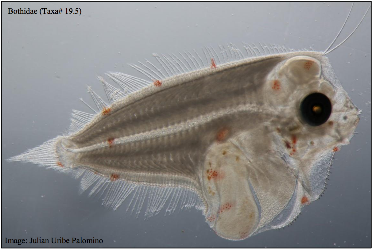
This dataset contains the ichthyoplankton data from three National Reference Stations on the east coast of Australia (North Stradbroke Island, Port Hacking, and Maria Island), and comparable historical data from eight ichthyoplankton surveys that were used to provide a longer term context: RV Sprightly (1983) RV Challenger (1989-1991) RV Franklin (1994) RV Franklin (1997-1998) RV Franklin (1998-1999) RV Southern Surveyor (2004) RV Investigator (2015) FRV Kapala (1989-1993) Refer to the published report which had the following goals: - To evaluate the value of long-term monitoring of ichthyoplankton at selected locations in the Integrated Marine Observing System (IMOS) National Reference Station (NRS) network, - To identify the potential of this monitoring for providing fishery-independent information relevant for marine fishes and their management. Note - Currently only the data from the IMOS NRS Stations have been made available.
-
Field surveys were undertaken at Marmion, Rottnest Island and Jurien Bay to measure the biomass of key taxa and benthic functional groups. Surveys of fish, invertebrate and western rock lobster were completed at 32 sites across the three regions. Within each of these three key regions, sites were identified as being either reef or seagrass habitat.