
Catalog

457 record(s)
Type of resources
Topics
Keywords
Contact for the resource
Provided by
Formats
Update frequencies
Status
draft
-
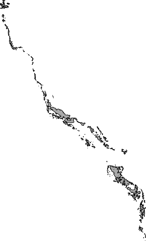
This dataset contains data collected by the Australian Continuous Plankton Recorder (AusCPR) survey and is funded by IMOS (Ships of Opportunity sub-facility) and CSIRO. The aims of the AusCPR survey are to: * map plankton biodiversity and distribution * develop the first long-term plankton baseline for Australian waters * document plankton changes in response to climate change * provide indices for fisheries management * detect harmful algal blooms * validate satellite remote sensing * initialise and test ecosystem models. The survey conducts repeat tows in the GBR, the East Australian Current and down to the Southern Ocean Time Series Mooring (SOTS). Other routes are conducted on an adhoc nature around Australia. The dataset also contains phytoplankton data from the UTAS / AAD led Southern Ocean CPR (SOCPR) project which is also funded by IMOS. The datasets available in this collection include Phytoplankton Colour Index (an estimate of chlorophyll in the water), phytoplankton abundance, zooplankton abundance and a biomass index from AusCPR and phytoplankton abundance from SOCPR. This data are freely available through the AODN portal: https://portal.aodn.org.au. This data is freely available but please acknowledge all relevant parties, as detailed in acknowledgement section.
-
This record contains data collected from the near-water surface sampling site off the Lucinda Jetty, as part of the Lucinda Jetty Coastal Observatory. Sample collection began the 9th of January, 2014. The data can be used for Ocean Colour sensor validation. Parameters measured include the absorption coefficients of the particulate and dissolved components of the water column and the phytoplankton pigment concentration and composition.
-
This resource describes a sample extent region for use in the Kaleidoscope spatial portal: https://kaleidoscope.terria.io/ No attribute data are presented.
-
This record describes multibeam echosounder data collected on voyage BF2020_v01 aboard the AMC's vessel the Bluefin. The vessel departed Beauty Point on the 11/08/2020 and returned to Beauty Point on the 17/08/2020. The Kongsberg EM2040c multibeam echosounder was used to acquire seafloor bathymetry, backscatter information and watercolumn backscatter. The survey area was ~4km to the south east of Golden Beach was ~6.2 km x ~15.4 km. (Area surveyed including turns totalled 103.7 km2). This survey area encompasses previously surveyed areas (2017 and 2018) and extended seaward to a depth of 26m. The EM2040c provides a 1.3 degree by 1.3 degree angular resolution. The echosounder's nominal frequency is 300 kHz and it operated in dual swath mode. This project also utilised a dual head arrangement enabling a greater swath coverage. Data are stored in *.all raw format for bathymetry and backscatter and *.wcd format for watercolumn backscatter at CSIRO. Raw data files include: - 545 *.all files totalling 195GB - 513 *.wcd files totalling 1.35TB Sound velocity profiles were applied to this data during data acquisition. Bathymetry data contained in *.all format are corrected for motion and position. Processed data was corrected to AHD utilising the AusGeoid2020 geoid model. Processed data had outliers removed. Processed line data are available in *.gsf format, and processed bathymetry and backscatter grids in geotiff format. Additional information regarding this dataset, including information on processing streams, is contained in the GSM data acquisition and processing report. Additional data products may be available on request.
-
This record describes scientific split-beam echosounder data collected from the Marine National Facility (MNF) RV Investigator Voyage IN2020_V08, titled "SOLACE - Southern Ocean Large Areal Carbon Export: quantifying carbon sequestration in subpolar and polar waters." The voyage took place between December 5, 2020 and January 16, 2021 departing from Hobart (TAS) and arriving in Hobart (TAS). The Simrad EK80 split beam echosounders 18, 38, 70 120, 200 and 333 kHz were used to acquire acoustic backscatter data to a range of 1500 m, at the three study locations and transit to and from Hobart . All frequencies were logged continuously for the extent of the voyage. Logging of "complex samples" occurred daily for one hour. Data are stored in *.raw (6273 files 625 GB) and *.idx (6273 files 63.0 MB) formats at CSIRO. No processing has been conducted on this data. Additional information regarding this dataset is contained in the GSM data acquisition and processing report. Additional data products may be available on request.
-

This record describes magnetometer data collected on RV Investigator voyage IN2020_V06, titled "Probing the Australian-Pacific Plate Boundary: Macquarie Ridge in 3-D." The voyage took place between October 8 and November 3, 2020 departing from Hobart (TAS) and arriving in Hobart (TAS). The SeaSPY2 magnetometer uses an omnidirectional Overhauser sensor that requires no realignment or recalibration and has no heading error. The instrument has an absolute accuracy of 0.1 nT, sensor sensitivity of 0.01 nT and resolution of 0.001 nT. Data are stored in .CSV and .MMS data files at CSIRO. 219 MB of raw data was acquired in this dataset. No processing has been conducted on this data. The magnetometer was towed 300 m astern of the ship and a layback value of 361 m was applied to the magnetometer data. This was the total distance behind the ship's positioning reference point. Additional information regarding this dataset is contained in the GSM data acquisition and processing report.
-

This record describes scientific split-beam echosounder data collected on the RV Investigator voyage IN2020_V09 (SOTS: Southern Ocean Time Series automated moorings for climate and carbon cycle studies southwest of Tasmania), which departed Hobart on the 27th August 2020 and returned to Hobart on the 12th September 2020. In addition to the tasks at the SOTS site the voyage also recovered a Rintoul mooring that was deployed during IN2020_V05. The Simrad EK80 wide band transceivers (WBT) 18, 38, 70, 120, 200 and 333 kHz, as well as the EK60 split-beam GPT 18kHz were used to acquire acoustic backscatter data to a range of 1500 m, during the voyage. All frequencies were logged sporadically (only when transiting) for the extent of the voyage. The frequencies were set to passive for the periods when stationary during the voyage. Note: the EK80 18kHz WBT failed at 12:06 on the 28th August 2020 (UTC) and was no longer used for the voyage. The 18kHz transducer was changed over to the EK60 GPT for the remainder of the voyage (in place of the 18kHz WBT). Data are stored in *.raw, *.bot and *.idx format at CSIRO. There are 291 files totalling 27.7 GB of raw data in this dataset. No processing has been conducted on this data. Additional information regarding this dataset is contained in the GSM data acquisition and processing report. Additional data products may be available on request.
-

This record describes magnetometer data collected on RV Investigator voyage voyage IN2020_E01 (Trials and Calibration) which departed Hobart on the 29th July 2020 and returned to Hobart on the 6th August 2020. The purpose of this voyage was to undertake post port-period equipment calibrations and commissioning, sea trials and personnel training. The SeaSPY2 magnetometer uses an omnidirectional Overhauser sensor that requires no realignment or recalibration and has no heading error. The instrument has an absolute accuracy of 0.1 nT, sensor sensitivity of 0.01 nT and resolution of 0.001 nT. Data are stored in .CSV and .MMS data files at CSIRO. 0.68 MB of raw data was acquired in this dataset. No processing has been conducted on this data. The magnetometer was towed 300 m astern of the ship and a layback value of 361 m was applied to the magnetometer data. This was the total distance behind the ship's positioning reference point. Note: The magnetometer was only deployed for a short period (between 23:04 & 23:51 on the 03/08/2020 - UTC) for training purposes only. Additional information regarding this dataset is contained in the GSM data acquisition and processing report.
-
This record describes scientific high-precision wide-band echosounder data collected on the RV Investigator voyage IN2020_V06, titled "Probing the Australian-Pacific Plate Boundary: Macquarie Ridge in 3-D." The voyage took place between October 8 and November 3, 2020 departing from Hobart (TAS) and arriving in Hobart (TAS). The Simrad EK80 split beam echosounders 18, 38, 70 120, 200 and 333 kHz were used to acquire acoustic backscatter data to a range of 1,500 m, around Macquarie Island and from Hobart transit. All frequencies were logged for the extent of the voyage, except where required to turn off for operational requirements. The frequencies were set to active for the whole period of the voyage. Data are stored in *.raw, *.bot and *.idx format at CSIRO. There are 818 files totalling 78.1 GB of raw data in this dataset. No processing has been conducted on this data. Additional information regarding this dataset is contained in the GSM data acquisition and processing report. Additional data products may be available on request.
-
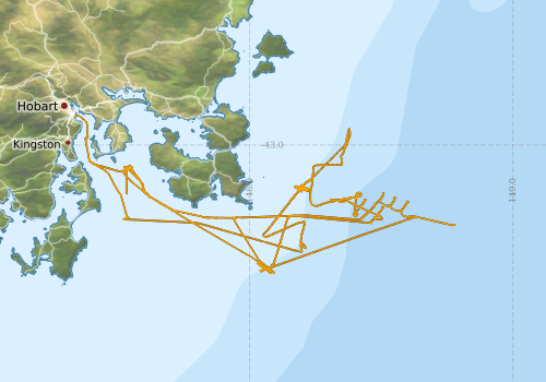
This record describes scientific split-beam echosounder data collected on the RV Investigator voyage IN2020_E01 (Trials and Calibration) which departed Hobart on the 29th July 2020 and returned to Hobart on the 6th August 2020. The purpose of this voyage was to undertake post port-period equipment calibrations and commissioning, sea trials and personnel training. The Simrad EK80 wide band transceivers (WBT) 18, 38, 70, 120, 200 and 333 kHz and the EK60 split-beam GPT 333 kHZ were calibrated at the start of this voyage at anchor in the Derwent Estuary on July 29, 2020. The EK80 WBTs were calibrated using default settings for both CW and FM modes. The EK80 system was then used to acquire acoustic backscatter data to a range of 1500 m for the remainder of the voyage offshore to the southeast of Tasman Peninsula. The EK60 split-beam GPTs for 18, 70, 120 and 200kHz were calibrated at anchor in the Derwent Estuary at the end of the voyage on August 6th, 2020. All frequencies were logged sporadically for the extent of the voyage. The frequencies were set to passive for periods during the voyage when conducting other system calibrations. Data are stored in *.raw, *.bot and *.idx format at CSIRO. There are 1,061 files totalling 99.9 GB of raw data in this dataset. No processing has been conducted on this data. Additional information regarding this dataset is contained in the GSM data acquisition and processing report. Additional data products may be available on request.