Keyword
Niskin Bottles
799 record(s)
Type of resources
Topics
Keywords
Contact for the resource
Provided by
Formats
Update frequencies
Status
draft
-
This record contains data collected from the near-water surface sampling site off the Lucinda Jetty, as part of the Lucinda Jetty Coastal Observatory. Sample collection began the 9th of January, 2014. The data can be used for Ocean Colour sensor validation. Parameters measured include the absorption coefficients of the particulate and dissolved components of the water column and the phytoplankton pigment concentration and composition.
-
This record describes PSA (Particle Size Analysis) data collected as part of the 1991-1993 Tasmanian Slope Trophodynamics Study undertaken by CSIRO Division of Fisheries. PSA data were obtained from Niskin bottle samples at a range of depths (surface to 1500 meters) on 4 cruises of FRV "Southern Surveyor" on three 60 km transects across the continental shelf to the south and south-east of Tasmania in July 1991 (cruise SS 02/91), February 1992 (cruise SS 01/92), November 1992 (cruise SS 04/92) and April 1993 (cruise SS 03/93). Analyses were later used to also derive approximate measurements of particulate carbon in the water column.
-
This record describes the dissolved oxygen data collected as part of the 1991-1993 Tasmanian Slope Trophodynamics Study undertaken by CSIRO Division of Fisheries. Samples for Dissolved Oxygen were taken from Niskin bottle samples at a range of depths (surface to 1500 meters) on 4 cruises of FRV "Southern Surveyor" on three 60 km transects across the continental shelf to the south and south-east of Tasmania in July 1991 (cruise SS 02/91), February 1992 (cruise SS 01/92), November 1992 (cruise SS 04/92) and April 1993 (cruise SS 03/93).
-

Chlorophyll a is the most commonly used indicator of phytoplankton biomass and is a proxy for primary productivity in the marine environment. It is relatively simple and cost effective to measure when compared to phytoplankton abundance and is thus routinely included in many surveys. Here we collate 173,333 records of chlorophyll a collected since 1965 from Australian waters gathered from researchers, from regular coastal monitoring surveys to long ocean voyages. This dataset concentrates on samples analysed using spectrophotometry, fluorometry and high performance liquid chromatography (HPLC). The Australian Chlorophyll a database is freely available through the Australian Ocean Data Network portal (http://imos.aodn.org.au/). These data can be used in isolation as an index of phytoplankton biomass or in combination with other data to provide insight into water quality, ecosystem state, and / or the relationships with other trophic levels such as zooplankton or fish.
-

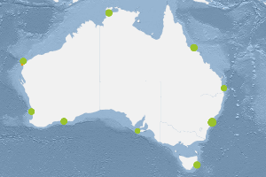
This dataset comprises the results of phytoplankton pigment composition analysed from samples collected as part of the Integrated Marine Observing Systems (IMOS) National Mooring Network - National Reference Station (NRS) field sampling. Pigment samples are taken for the complete water column (0-50m) and at the depths of the shallow WQM and the deeper WQM attached to the mooring at that site. Nine Sites are included in the IMOS NRS field sampling stations. Maria Island (TAS), Kangaroo Island (SA), Esperance (WA), Rottnest Island (WA), Ningaloo (WA), Darwin (NT), Yongala (QLD), North Stradbroke Island (QLD) and Port Hacking 100 (NSW). Sampling at these sites is conducted by several members of IMOS NRS Biogeochemical project. Sampling at the sites began between 29/9/2008 and 8/11/2010 and is currently ongoing for 7 sites. Sampling ceased at Ningaloo and Esperance (WA) sites in Aug/Sept 2013. Sampling is conducted monthly (Esperance and Ningaloo were 3 monthly) off small vessels. Depths sampled range from surface to 105 metres depending on the site. Depths are usually sampled at 10 metre intervals. Details including information on station locations, depths sampled and sample types collected are shown in the PDF link below extracted from the IMOS NRS NATIONAL REFERENCE STATIONS BIOGEOCHEMICAL OPERATIONS - A PRACTICAL HANDBOOK, Version 2.2 July 2012. A link to the full handbook is also provided which includes full details of the sampling regime and analyses. Historical data collected as part of CSIRO Coastal Monitoring program is available for three of the National Reference Station sites: Maria Island Coastal Station Data 1944-2008, Port Hacking 100m Coastal Station Data 1953-2010 and Rottnest Island Coastal Station Data 1951-2009. The links to the metadata and access for these data is provided below. Data storage and access is planned to be interoperable with other national and international programs through the IMOS Infrastructure. Station metadata can be found through this resource. Data is freely available through the AODN portal: https://portal.aodn.org.au
-
This record describes chlorophyll data collected as part of the 1991-1993 Tasmanian Slope Trophodynamics Study undertaken by CSIRO Division of Fisheries. Chlorophyll data were obtained from analyses of filters from Niskin bottle samples at a range of depths (surface to 1500 meters) on 4 cruises of FRV "Southern Surveyor" on three 60 km transects across the continental shelf to the south and south-east of Tasmania in July 1991 (cruise SS 02/91), February 1992 (cruise SS 01/92), November 1992 (cruise SS 04/92) and April 1993 (cruise SS 03/93). Analyses were carried out using spectrophotometric methods (cruise SS 01/92) and HPLC (3 remaining cruises), and analysed for chlorophylls a, b and c to give estimates of algal biomass in the water.
-
Nutrients in Albatross Bay, Gulf of Carpentaria, northern Australia, were examined monthly between August 1991 and April 1992. Levels of nitrate, nitrite, phosphate and silicate were measured, at four sites, at different depths in the water column.
-
Phytoplankton pigment composition (chlorophyll a concentration) was measured in Albatross Bay, Gulf of Carpentaria, northern Australia. Four sites were sampled over six years between August 1986 and April 1992. In the last two years samples were taken at the bottom of the water column in addition to mid-depth.
-
This dataset contains the Hydrology (HYD) data collected on Franklin voyage FR 03/1985. The voyage took place in the Tasman and Coral Seas during 8-27 June 1985. This dataset has been processed and archived within the CSIRO Marine and Atmospheric Research Data Centre in Hobart. Additional information regarding this dataset is contained in the cruise report for this voyage and/or the data processing report (as available). Franklin on-voyage hydrology data are typically obtained from water samples collected in Niskin bottles at various depths during each CTD cast. Parameters measured normally comprise temperature, salinity, dissolved oxygen, phosphate, nitrate, silicate and nitrite.
-
This dataset contains nutrient, temperature, salinity, chlorophyll a, suspended solids and light data from Jervis Bay, NSW. The data were obtained from 9 sites around Jervis Bay, every 3 months between 1989 and 1991. Data from monthly sampling for 2 years from 5 sites were also obtained. The data are part of the Jervis Bay Marine Ecological Study. NB - As the database has been lost, the only data still available are those published in the JERVIS BAY BASELINE STUDIES Final Report.
