
Representation type
grid
2 record(s)
Type of resources
Topics
Keywords
Contact for the resource
Provided by
Years
Formats
Representation types
Update frequencies
Status
draft
-
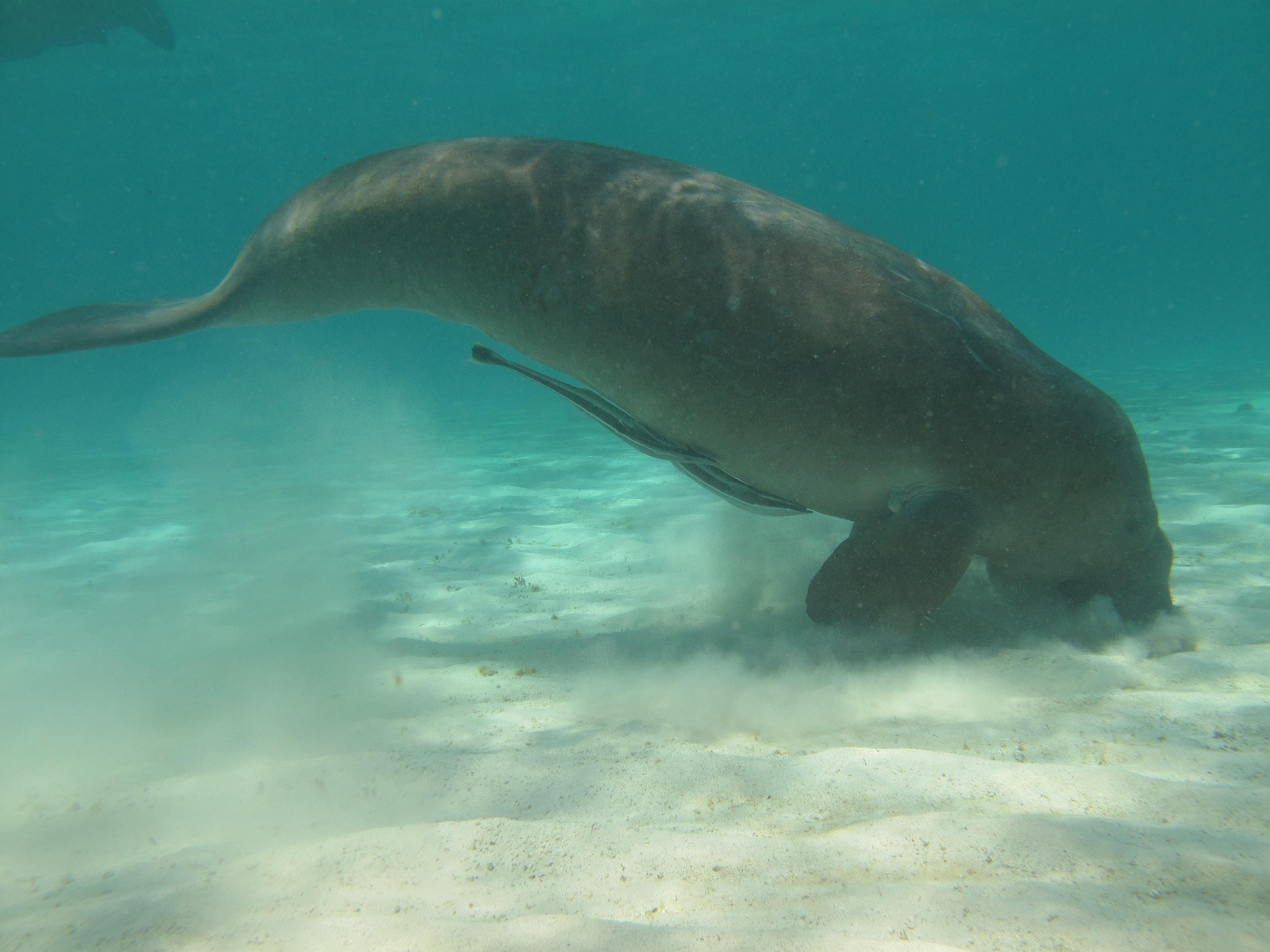
Dugongs (Dugong dugon) are listed as vulnerable on the IUCN Red List of Threatened species and as other specially protected fauna in WA under Schedule 7 of the Wildlife Conservation (Specially Protected Fauna) Notice 2015). Gaps in our knowledge in Western Australia include having a good understanding of the species’ distribution, abundance and high use areas across the northwest. This 3-year project (2014-2017) integrated Indigenous knowledge and scientific observations from field surveys to better understand the distribution, abundance and movements of dugong in the Kimberley region. The data collected also provides a baseline for future monitoring and management. This medata record relates to raw and processed aerial survey data of marine fauna collected between 21st September 2015 and 8th October 2015 in Kimberley coastal waters to the 20m bathymetry line, comprising dugongs (Dugong dugon), Australian snubfin dolphins (Orcaella heinsohni), other dolphins (bottlenose, spinners, false killer whales), humpback whales (Megaptera novaeangliae) and large, mostly green turtles (Chelonia mydas). The WA Department of Biodiversity Conservation and Attractions (DBCA, ex-DPaW) and CSIRO provided additional resources to extend the North Kimberley dugong aerial survey boundary westwards (Broome to just past Port Hedland) to cover the South Kimberley-Pilbara coastal regions, to close the last remaining knowledge gap of the dugong distribution and abundance in Australia. This additional survey was completed in May 2017. Data from a trial movement study undertaken between 1-18th August 2016 also forms part of this metadata record. Five dugongs were tagged with Telonics manatee/dugong tags. GPS and ARGOS satellite detection locations and dive data were downloaded weekly from the ARGOS web site.
-
This data is a combination of records held by the Australian Maritime Safety Authority. From 1999 to 2011 Australia shipping was tracked through the Australian Ship Reporting System (AUSREP). From 2012 onward this changed to the Automatic Identification System (AIS). The data presented here are summaries of the tracks of vessels between the points identified by either AUSREP or AIS, summarised to the number of KM per 0.1 deg grid square. The AIS is a Very High Frequency (VHF) radio broadcasting system which enables AIS equipped vessels and shore-based stations to send and receive identifying information. This information can: be displayed on a computer or chart plotter aid in situational awareness provide a means to assist in collision avoidance. The International Maritime Organization (IMO) defines AIS as a ship and shore based broadcast system, operating in the VHF maritime band. The AIS can handle over 2,000 reports per minute and may update information as often as every two seconds. https://www.amsa.gov.au/navigation/services/ais/ Australian Ship Reporting System (AUSREP) is a ship reporting system designed to contribute to the safety of life at sea and is operated by the Australian Maritime Safety Authority (AMSA) through the Australian Rescue Coordination Centre (RCC Australia) in Canberra. Participation in AUSREP is mandatory for certain ships but most other commercial ships participate voluntarily. Shipmasters send a position report each day at a convenient time nominated by the ship, the maximum time between any two reports is not to exceed 24 hours. The data is used as reference material only, designed to indicate shipping lanes and the number of vessels moving through Australian waters. AUSREP commenced in 1973 in line with Australia's obligations under the International Convention for the Safety of Life at Sea (SOLAS) as a ship reporting system and is operated by AMSA through the RCC Australia in Canberra. https://www.operations.amsa.gov.au/Spatial/DataServices/MapProduct