
Keyword
Coastal Waters (Australia) | New South Wales Coast, NSW
688 record(s)
Type of resources
Topics
Keywords
Contact for the resource
Provided by
Formats
Update frequencies
Status
draft
-
This record contains fisheries statistics, History of Marine Animal Populations, trawling, overfishing from the Australian fishing industry between 1918 and 1923.
-

This record describes the Carthe Drifter data from the Marine National Facility (MNF) RV Investigator voyage IN2023_V06, titled "Understanding Eddy Interactions and Their Impacts in the East Australian Current System." The voyage took place between October 9, 2023 and November 2, 2023 (AEST), departing from Sydney and returning to Sydney. Four carthe drifters were deployed near the Solitary and Richmond Canyons to characterise near-surface circulation associated with the East Australian Current. Drifter trajectories captured the strength and variability of surface flow and cross-shelf transport, providing Lagrangian observations of EAC-driven circulation and its influence on shelf–slope exchange.
-
This record contains fisheries statistics, History of Marine Animal Populations, trawling, overfishing from the Australian fishing industry between 1951 and 1957.
-
This record contains fisheries statistics, History of Marine Animal Populations, trawling, overfishing from the Australian fishing industry between 1937 and 1943.
-
This record describes multibeam echosounder data collected on Bluefin voyage BF2019_V01, 'Hydrographic Survey of the Freycinet, Huon and Tasman Fracture Australian Marine Parks' which departed Hobart, Tasmania on the 8th March 2019 and returned to Beauty Point, Tasmania on the 22nd March 2019. CSIRO’s Geophysical Survey and Mapping, Shallow Survey Facility (SSF) was contracted by the Institute for Marine and Antarctic Studies (IMAS) of the University of Tasmania (UTAS) in collaboration with Parks Australia, to undertake a 2 week hydrographic survey of the Freycinet Australian Marine Park to complete surveying of the Park out to approximately 300 m. Depending on weather conditions further surveying of the Huon and Tasman Fracture sites could also be attempted. Two sites, Pedra and South West Cape survey areas, were undertaken for comparison data outside of Marine Park areas. Nick Dando from Geoscience Australia (GA) mobilised their Kongsberg EM2040c Mulitbeam Echosounder (MBES) system onboard the MV Bluefin in Hobart on Thursday and Friday 7-8 March with assistance from Stuart Edwards, Craig Davey and Bernadette Heaney, CSIRO. Divers from IMAS attached the transducer to the hull of the ship. The GA system also included a POSMV navigation system, a Valeport sound velocity profiler (and a spare profiler) Bridge display laptop and Bridge display screen. The Kongsberg EM2040c multibeam echosounder was used to acquire seafloor bathymetry and backscatter information and watercolumn backscatter at the Freycinet, Huon and Tasman Fracture Australian Marine Parks surrounding south and south eastern Tasmania. The EM2040c provides a 1.3° by 1.3° transmit and receive angular resolution respectively. The echosounder's nominal frequency was 300 kHz and was operated in dual swath mode. Data are stored in *.all raw format for bathymetry and backscatter and *.wcd format for watercolumn backscatter at CSIRO. Sound velocity profiles were applied to this data during data acquisition. Bathymetry data contained in *.all format are corrected for motion and position. Tide corrections were not applied to the final processed dataset. Instead the data was mapped to the ellipsoid (GPS Height) and thereafter reduced to AHD (Australian Height Datum) using the AusGeoid09 model. Processed data has had outliers removed. Processed line data are available in *.gsf and ascii format, and processed bathymetry and backscatter grids in geotiff format. Additional information regarding this dataset, including further information on processing streams, is contained in the GSM data acquisition and processing reports. Additional data products may be available on request.
-
This record describes multibeam echosounder data collected on RV Investigator voyage IN2017_V04, 'The whole enchilada: from production to predation in Tasman Sea ecosystems' which departed Brisbane on the 31-Aug-2017 and returned to Sydney on the 18 September 2017. The Kongsberg EM710 MKII multibeam echosounder was used to acquire seafloor bathymetry and backscatter information. The EM710 MKII provides a 0.5° by 1° transmit and receive angular resolution respectively. The echosounder's nominal frequency range is from 40 to 100 kHz. Data are stored in *.all raw format for bathymetry and backscatter and *.wcd format for watercolumn backscatter at CSIRO. There are 91 files totalling 23.5 GB of raw data in this dataset. Sound velocity profiles were applied to this data during data acquisition. Bathymetry data contained in *.all format are corrected for motion and position. Tide corrections were not applied to the processed data. Processed data has had outliers removed. Processed line data are available in *.gsf and ascii format. Additional information regarding this dataset, including further information on processing streams, is contained in the GSM data acquisition and processing report. Additional data products may be available on request.
-
This record describes SVP data collected on IN2020_E01 (Trials and Calibration) which departed Hobart on the 29th July 2020 and returned to Hobart on the 6th August 2020. The purpose of this voyage was to undertake post port-period equipment calibrations and commissioning, sea trials and personnel training. A total of 7 SVP casts were conducted over the duration of this voyage using the Valeport rapidSV profiler. Data are stored in ASCII format files with extension *.txt at CSIRO. A total of 5 SVP casts were conducted over the duration of this voyage using the Valeport Midas SVX2 profiler. Data are stored in ASCII format files with extension *.000 at CSIRO. Additional information regarding this dataset is contained in the GSM data acquisition and processing report. Additional data products may be available on request.
-

This record describes multibeam echosounder data collected on RV Investigator voyage IN2021_V01, titled: "Quantifying krill abundance for krill monitoring and management off the Australian Antarctic Territory," which departed Hobart on the 29th January 2021 and returned to Hobart on the 24th March 2021 (AEST). The Kongsberg EM710 MKII multibeam echosounder was used to acquire seafloor bathymetry, backscatter information and watercolumn backscatter for only a short duration at the beginining of the voyage, followed by two short periods to assess mooring deployment locations. Mooring deployment site surveys carried out with the EM710 MKII were in the vicinity of the Antarctic shelf-break region with locations of approx. 66°57.2'S, 75°00.5'E & 66°32'S, 62°13'E. The EM710 MKII provides a 0.5° by 1° transmit and receive angular resolution respectively. The echosounder's nominal frequency range is from 40 to 100 kHz. Data are stored in *.all raw format for bathymetry and backscatter and *.wcd format for watercolumn backscatter at CSIRO. There are 47 files totalling 15.82GB of raw data in this dataset. Sound velocity profiles were applied to this data during data acquisition. Bathymetry data contained in *.all format are corrected for motion and position. The data have been reduced to approximate Mean Sea Level (MSL) using the Earth Gravitation Model 2008 (EGM2008) 1 arc-minute grid. Tide corrections were not applied to the processed data. Processed data has had outliers removed. Processed line data are available in *.gsf and ascii format, and processed bathymetry and backscatter grids in geotiff format. Additional information regarding this dataset, including further information on processing streams, is contained in the GSM data acquisition and processing report. Additional data products may be available on request.
-
This record describes multibeam echosounder data collected on RV Investigator voyage IN2020_V10, titled MNF Trials, Storm Bay Modelling and Information System Data Collection, and Bathymetric and Benthic Habitat mapping of the Huon AMP. The voyage took place from 11-22 November 2021 departing from Hobart (TAS) and returning to Hobart (TAS). The Kongsberg EM710 MKII multibeam echosounder was used to acquire seafloor bathymetry, backscatter information and watercolumn backscatter through the shelf-break region and seamount clusters within Huon AMP. The EM710 MKII provides a 0.5° by 1° transmit and receive angular resolution respectively. The echosounder's nominal frequency range is from 40 to 100 kHz. Data are stored in *.all raw format for bathymetry and backscatter and *.wcd format for watercolumn backscatter at CSIRO. There are: - 196 raw *.all files totalling 4.32GB in this dataset. - 25 raw *.wcd files totalling 49.6GB in this dataset Sound velocity profiles were applied to this data during data acquisition. Bathymetry data contained in *.all format are corrected for motion and position. Tide corrections were not applied to the processed data. Processed data has had outliers removed. Processed line data are available in *.gsf and ascii format, and processed bathymetry and backscatter grids in geotiff format. Additional information regarding this dataset, including further information on processing streams, is contained in the GSM data acquisition and processing report. Additional data products may be available on request.
-
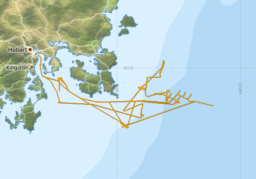
This record describes SVP data collected on RV Investigator voyage IN2020_v10, which departed Hobart 11/11/2020, and arrived Hobart 22/11/2020. A total of 14 SVP casts were conducted over the duration of this voyage. Casts were conducted using a Teledyne Oceanscience RadipcastSV. Data are stored in ASCII format files with extention *.txt at CSIRO. Additional information regarding this dataset is contained in the GSM data acquisition and processing report. Additional data products may be available on request.