Keyword
Countries | Papua New Guinea
8 record(s)
Type of resources
Topics
Keywords
Contact for the resource
Provided by
Formats
Update frequencies
Status
draft
-

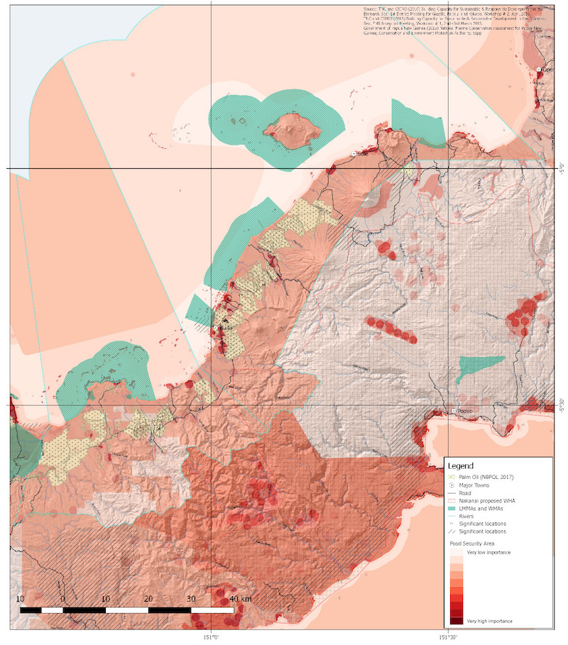
We have developed a framework for collating and presenting information on the values of marine and coastal ecosystems to relevant stakeholders for planning and decision making tasks in New Britian, Papua New Guinea. The framework includes the following design criteria: • Includes a comprehensive range of value types, including socio-cultural, economic and ecosystem values, and all four ecosystem services types (provisioning, cultural, regulating and supporting). • Has the ability to reflect the different value (scalar) contexts of local, Provincial and National stakeholders. • Is spatial, being based on ecosystem feature layers. • Has the capacity to be spatially comprehensive, by including a full range of ecosystem features in the focus area. • Does not rely on monetisation or attempt to calculate a single value (e.g. TEV), but rather relies on a plurality of values. Attempts to presents information in a transparent, relevant, replicable and credible way. Our approach is built on contemporary approaches to the valuation of ecosystems for planning and management. This includes the expression of pluralist values and appropriate consideration of scale. Pluralist values recognises that there is value in reflecting a broad range of value types when considering the value of ecosystems across ecological, socio-cultural and economic values. There are four categories of values represented in the framework: ecosystem structure and processes (biodiversity, productivity, connectivity); ecosystem regulatory functions (climate, pest, and pollution regulation; hazard protection); ecosystem goods and services supply (food, fibre and fuel); and shared social values (spiritual, aesthetic, recreation, existence values). This represents a comprehensive range of value types as defined by a range of valuing frames, including ecosystem services, economic valuation and socio-cultural valuing approaches. A fundamental basis of our framework is that it is feature based – including both ecosystem and man-made features. The full range of socio-cultural, economic and ecological values can then be associated with that feature, and these can then be overlain in spatial systems to produce a comprehensive spatial valuation. In addition, the socio-cultural values associated with man-made features (such historical wrecks, buildings etc.) can be captured in the spatial values system.
-

This record describes XBT data collected on RV Investigator voyage IN2019_V04, which departed Hobart on the 11 April 2019 and returned to Hobart on the 23 April 2019. A total of 2 XBT casts were conducted over the duration of this voyage. Both were undertaken in quick succession in the same location. Data are stored in netCDF files at CSIRO. Additional information regarding this dataset is contained in the GSM data acquisition and processing report. Additional data products may be available on request.
-

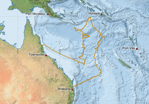
This record describes sub bottom profiler data collected on RV Investigator voyage IN2019_V04, 'Hotspot dynamics in the Coral Sea: connections between the Australian plate and deep Earth' which departed Cairns on the 7th August 2019 and returned to Brisbane on the 3rd September 2019. The Kongsberg SBP120 (sub bottom profiler) was used to acquire data, containing the specular reflections at different sediment interfaces below the seafloor, in the Coral Sea within the EEZ of Australia, Papua New Guinea, Solomon Islands and New Caledonia The SBP120 provides a 3° by 3° angular resolution. The echosounder's frequency sweep range is from 2.5 to 7 kHz. The SBP120 was logged continuously whilst underway during the voyage. Data are stored in *.raw (859 files 19.3 GB) raw and *.seg (868 files 19.7 GB) segy formats at CSIRO. There are additional *.seg files due to line splitting that was required. The segy format data had a real time processing stream applied, which applies gain, a gain correction, matched filter with replica shaping and time variable gain. Instantaneous amplitude was not applied in the processing stream. Additional information regarding this dataset is contained in the GSM data acquisition and processing report. Additional data products may be available on request
-

This record describes gravity data collected on RV Investigator voyage IN2019_V04, 'Hotspot dynamics in the Coral Sea: connections between the Australian plate and deep Earth' which departed Cairns on the 7th August 2019 and returned to Brisbane on the 3rd September 2019. The gravity meter instrument is a MicroG Lacoste Air-Sea II and was run continuously during the voyage in the Coral Sea, within the EEZ of Australia, Papua New Guinea, Solomon Islands and New Caledonia. Data are stored in .ENV and .DAT data files at CSIRO. There are 57 files totalling 463 MB of raw data in this dataset. Wharf ties were undertaken at the start and end of the voyage using a Scintrex Autograv CG-5. Reference station number 2008909952 was used in Cairns (located at Cairns airport) and station number 2016909147 was used in Brisbane (located at Northshore Riverside Park). Wharf tie data can be found in "Cairns_wharf_gravity_tie_in2019_v04.TXT" and "Brisbane_wharf_gravity_tie_post_in2019_v04.TXT", which are stored with the raw data folder. No processing has been conducted on this data. Additional information regarding this dataset is contained in the GSM data acquisition and processing report.
-

This record describes magnetometer data collected on RV Investigator voyage IN2019_V04, 'Hotspot dynamics in the Coral Sea: connections between the Australian plate and deep Earth' which departed Cairns on the 7th August 2019 and returned to Brisbane on the 3rd September 2019. The instrument is a Marine Magnetics SeaSPY2 magnetometer and was deployed while transiting during the voyage in the Coral Sea, within the EEZ of Australia, Papua New Guinea, Solomon Islands and New Caledonia. Data are stored in .CSV and .MMS data files at CSIRO. 872 MB of raw data was acquired in this dataset. No processing has been conducted on this data. The SeaSPY2 magnetometer uses an omnidirectional Overhauser sensor that requires no realignment or recalibration and has no heading error. The instrument has an absolute accuracy of 0.1 nT, sensor sensitivity of 0.01 nT and resolution of 0.001 nT.” The magnetometer was towed 300m astern of the ship and a layback value of 361m was applied to the magnetometer data. This was the total distance behind the ship's positioning reference point. Additional information regarding this dataset is contained in the GSM data acquisition and processing report.
-

This record describes multibeam echosounder data collected on RV Investigator voyage IN2019_V04, 'Hotspot dynamics in the Coral Sea: connections between the Australian plate and deep Earth', which departed Cairns on the 7th August 2019 and returned to Brisbane on the 3rd September 2019. The Kongsberg EM122 multibeam echosounder was used to acquire seafloor bathymetry, backscatter information and watercolumn backscatter in the Coral Sea, within the EEZ of Australia, Papua New Guinea, Solomon Islands and New Caledonia. The EM122 provides a 1 degree by 1 degree angular resolution. The echosounder's nominal frequency is 12 kHz. Data are stored in *.all raw format for bathymetry and backscatter and *.wcd format for watercolumn backscatter at CSIRO. There are 977 files totalling 49.2 GB of raw data in this dataset. Sound velocity profiles were applied to this data during data acquisition. Bathymetry data contained in *.all format are corrected for motion and position. Tide corrections were not applied to the processed data. Processed data had outliers removed. Processed line data are available in *.gsf and ascii format, and processed bathymetry and backscatter grids in geotiff format. Additional information regarding this dataset, including information on processing streams, is contained in the GSM data acquisition and processing report. Additional data products may be available on request.
-

This record describes scientific split-beam echosounder data collected on the RV Investigator voyage IN2019_V04, 'Hotspot dynamics in the Coral Sea: connections between the Australian plate and deep Earth', which departed Cairns on the 7th August 2019 and returned to Brisbane on the 3rd September 2019. The Simrad EK60 split beam echosounders 18, 38, 70 120, 200 and 333 kHz were used to acquire acoustic backscatter data to a range of 1500 m in the Coral Sea, within the EEZ of Australia, Papua New Guinea, Solomon Islands and New Caledonia. All frequencies were logged continuously for the extent of the voyage. Data are stored in *.raw, *.bot and *.idx format at CSIRO. There are 766 files totalling 73.9 GB of raw data in this dataset. No processing has been conducted on this data. Additional information regarding this dataset is contained in the GSM data acquisition and processing report. Additional data products may be available on request.
-
The O&A Trajectory data set includes data collected during the voyages of Australia's Marine National Facility and CSIRO marine research vessels. Trajectory data typically consists of undulating CTD track point data. The subset extracted for MARVL contains data on the continental shelf as defined by the 200 metre depth contour from the 2012 Bathymetric dataset merged (spatial union) with the Exclusive Economic Zone (EEZ) in the Australian Maritime Boundary dataset (http://www.ga.gov.au/metadata-gateway/metadata/record/gcat_63565) available from Geosciences Australia (GA). This subset of the data contains 867,617 position records from 14 voyages and includes water temperature, pressure, water depth, fluorescence and salinity (derived) and spans from 1995 to the present. The full data set is held in the O&A Information & Datacentre Data Warehouse, which currently holds over 3,124,509 position records from 31 voyages collected since 1988. This data includes water temperature, pressure, water depth, fluorescence, salinity (derived), oxygen, eco chloro, eco cdom and eco bp. Individual metadata records have been created for each research voyage.
