
Keyword
Shallow Swath Internal Facility
9 record(s)
Type of resources
Topics
Keywords
Contact for the resource
Provided by
Formats
Update frequencies
Status
draft
-
This record describes multibeam echosounder data collected on voyage BF2020_v01 aboard the AMC's vessel the Bluefin. The vessel departed Beauty Point on the 11/08/2020 and returned to Beauty Point on the 17/08/2020. The Kongsberg EM2040c multibeam echosounder was used to acquire seafloor bathymetry, backscatter information and watercolumn backscatter. The survey area was ~4km to the south east of Golden Beach was ~6.2 km x ~15.4 km. (Area surveyed including turns totalled 103.7 km2). This survey area encompasses previously surveyed areas (2017 and 2018) and extended seaward to a depth of 26m. The EM2040c provides a 1.3 degree by 1.3 degree angular resolution. The echosounder's nominal frequency is 300 kHz and it operated in dual swath mode. This project also utilised a dual head arrangement enabling a greater swath coverage. Data are stored in *.all raw format for bathymetry and backscatter and *.wcd format for watercolumn backscatter at CSIRO. Raw data files include: - 545 *.all files totalling 195GB - 513 *.wcd files totalling 1.35TB Sound velocity profiles were applied to this data during data acquisition. Bathymetry data contained in *.all format are corrected for motion and position. Processed data was corrected to AHD utilising the AusGeoid2020 geoid model. Processed data had outliers removed. Processed line data are available in *.gsf format, and processed bathymetry and backscatter grids in geotiff format. Additional information regarding this dataset, including information on processing streams, is contained in the GSM data acquisition and processing report. Additional data products may be available on request.
-

This record describes multibeam echosounder data collected on RV Linnaeus voyage LI2019_V01, 'Ningaloo Deepwater Reefs Hydrographic Survey' which departed Hillary's Boat Harbour, Perth, WA on the 15th March 2019 and concluded at Coral Bay, WA on the 29th March 2019. The Kongsberg EM2040c multibeam echosounder (single transceiver) was used to acquire seafloor bathymetry and backscatter information (and watercolumn backscatter) offshores of Ningaloo Reef, WA. Transit data to and from nightly anchorages has also been recorded. The EM2040c provides a 1.3° by 1.3° transmit and receive angular resolution respectively (single transceiver). The echosounder's nominal frequency range was 200 kHz and it was operated in dual swath mode. Data are stored in *.all raw format for bathymetry and backscatter and *.wcd format for watercolumn backscatter at CSIRO. There are 140 files totalling 32.5 GB of raw .all data, and 103 files totalling 178 GB of raw .wcd in the dataset. Sound velocity profiles were applied to this data during data acquisition. Bathymetry data contained in *.all format are corrected for motion and position. Tide corrections were applied to the processed data in Caris using a GPS Tide based on the Applanix PosMV and Marinestar G4+ Ellipsoidal ht and thereafter reduced to AHD (Australian Height Datum) using a AusGeoid09 model. Processed data has had outliers removed. Processed line data are available in *.gsf and ascii format, and processed bathymetry and backscatter grids in geotiff format. Additional information regarding this dataset, including further information on processing streams, is contained in the GSM data acquisition and processing report. Additional data products may be available on request. The raw data is offline but is available on request.
-
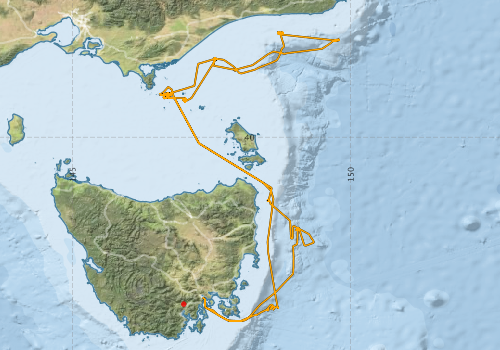
This record describes multibeam echosounder data collected on Bluefin voyage BF2019_V01, 'Hydrographic Survey of the Freycinet, Huon and Tasman Fracture Australian Marine Parks' which departed Hobart, Tasmania on the 8th March 2019 and returned to Beauty Point, Tasmania on the 22nd March 2019. CSIRO’s Geophysical Survey and Mapping, Shallow Survey Facility (SSF) was contracted by the Institute for Marine and Antarctic Studies (IMAS) of the University of Tasmania (UTAS) in collaboration with Parks Australia, to undertake a 2 week hydrographic survey of the Freycinet Australian Marine Park to complete surveying of the Park out to approximately 300 m. Depending on weather conditions further surveying of the Huon and Tasman Fracture sites could also be attempted. Two sites, Pedra and South West Cape survey areas, were undertaken for comparison data outside of Marine Park areas. Nick Dando from Geoscience Australia (GA) mobilised their Kongsberg EM2040c Mulitbeam Echosounder (MBES) system onboard the MV Bluefin in Hobart on Thursday and Friday 7-8 March with assistance from Stuart Edwards, Craig Davey and Bernadette Heaney, CSIRO. Divers from IMAS attached the transducer to the hull of the ship. The GA system also included a POSMV navigation system, a Valeport sound velocity profiler (and a spare profiler) Bridge display laptop and Bridge display screen. The Kongsberg EM2040c multibeam echosounder was used to acquire seafloor bathymetry and backscatter information and watercolumn backscatter at the Freycinet, Huon and Tasman Fracture Australian Marine Parks surrounding south and south eastern Tasmania. The EM2040c provides a 1.3° by 1.3° transmit and receive angular resolution respectively. The echosounder's nominal frequency was 300 kHz and was operated in dual swath mode. Data are stored in *.all raw format for bathymetry and backscatter and *.wcd format for watercolumn backscatter at CSIRO. Sound velocity profiles were applied to this data during data acquisition. Bathymetry data contained in *.all format are corrected for motion and position. Tide corrections were not applied to the final processed dataset. Instead the data was mapped to the ellipsoid (GPS Height) and thereafter reduced to AHD (Australian Height Datum) using the AusGeoid09 model. Processed data has had outliers removed. Processed line data are available in *.gsf and ascii format, and processed bathymetry and backscatter grids in geotiff format. Additional information regarding this dataset, including further information on processing streams, is contained in the GSM data acquisition and processing reports. Additional data products may be available on request.
-
This record describes multibeam echosounder data collected on RV Investigator voyage IN2022_V07, HALO - Halimeda bioherm Origins, function and fate in the northern Great Barrier Reef." The voyage took place between August 15, 2022 and September 7, 2022 (AEST), departing from Brisbane and returning to Cairns. Piggyback project: Dinoflagellates & broader planktonic assemblage observation. The Dual-Head Kongsberg EM2040c multibeam echosounder was used to acquire seafloor bathymetry, backscatter information and watercolumn backscatter at 3 focused site north of Cairns. An additional site, Lowry passage, was also systematically surveyed with the system. The EM2040c provides a 1.3 degree by 1.3 degree angular resolution. The echosounder's nominal frequency is 300 kHz and it operated in dual-head single swath mode. Data are stored in *.all raw format for bathymetry and backscatter and *.wcd format for watercolumn backscatter at CSIRO. There are 701 files totalling 174 GB of raw data in this dataset. Sound velocity profiles were applied to this data during data acquisition. Bathymetry data contained in *.all format are corrected for motion and position. Predicted tides calculated in AusTides 2022 were applied to the processed data relative to MSL. Processed data had outliers removed. Processed line data are available in *.gsf and ascii format, and processed bathymetry and backscatter grids in geotiff format. Additional information regarding this dataset, including information on processing streams, is contained in the GSM data acquisition and processing report. Additional data products may be available on request.
-
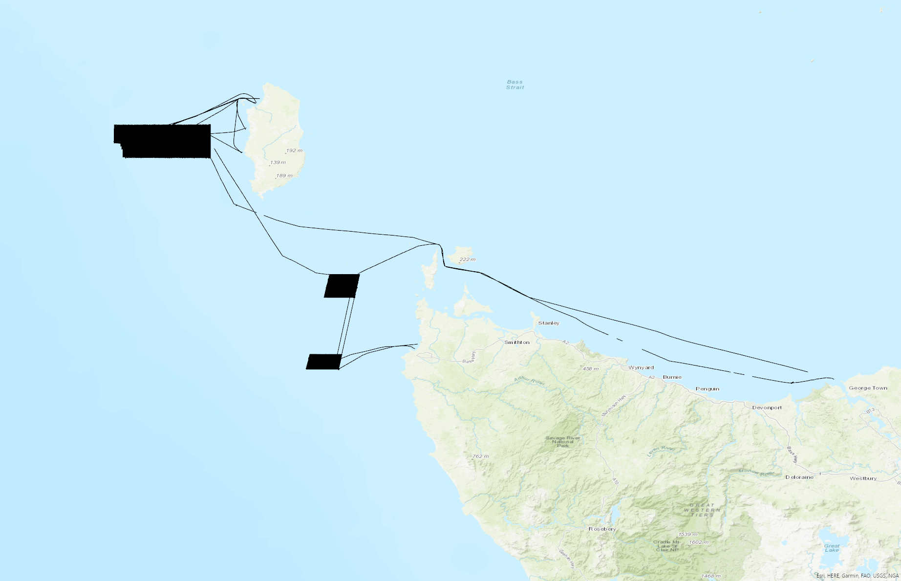
This record describes multibeam echosounder data collected on voyage BF2022_V01 aboard the AMC's vessel the Bluefin. The vessel departed Beauty Point on the 28/02/2022 and returned to Beauty Point on the 21/03/2022. The Kongsberg EM2040c multibeam echosounder was used to acquire seafloor bathymetry, backscatter information and watercolumn backscatter. The surveyed areas include Zeehan Marine Park, west of King Island and the Franklin Marine Park, west of Marrawah (NW Tasmania). A total surveyed area was 1026.2 km² not (including transits) comprising Zeehan Marine Park 726 km² and Franklin Marine Park 300.2 km². The EM2040c provides a 1.3 degree by 1.3 degree angular resolution. The echosounder's nominal frequency is 300 kHz and it operated in dual swath mode. Data are stored in *.all raw format for bathymetry and backscatter and *.wcd format for watercolumn backscatter at CSIRO. Raw data files include: - 751 *.all files totalling 237GB - 728 *.wcd files totalling 1.55TB Sound velocity profiles were applied to this data during data acquisition. Bathymetry data contained in *.all format are corrected for motion and position. Processed data was corrected to MSL utilising the EGM2008 geoid model. Processed data had outliers removed. Processed line data are available in *.gsf format, and processed bathymetry and backscatter grids in geotiff format. Additional information regarding this dataset, including information on processing streams, is contained in the GSM data acquisition and processing report. Additional data products may be available on request.
-
This record describes multibeam echosounder data collected on RV Investigator voyage IN2019_V07, 'RAN Hydrographic and Maritime Heritage Surveys' which departed Hobart on the 11 April 2019 and returned to Hobart on the 23 April 2019. The Kongsberg EM710 MKII multibeam echosounder was used to acquire seafloor bathymetry and backscatter information [and watercolumn backscatter] along the Tasmanian East coast and in the central to eastern region of Bass Strait. The EM710 MKII provides a 0.5° by 1° transmit and receive angular resolution respectively. The echosounder's nominal frequency range is from 40 to 100 kHz. Data are stored in *.all raw format for bathymetry and backscatter and *.wcd format for watercolumn backscatter at CSIRO. There are 337 files totalling 67 GB of raw data in this dataset. Sound velocity profiles were applied to this data during data acquisition. Bathymetry data contained in *.all format are corrected for motion and position. Tide corrections were applied to some of the processed data (i.e. AHO mapping area - files 0037 to 0112, and to other mapping sites - files 0188 to 0256). GPS tides (and reduction to AHD using AusGeoid 09) was applied to the BMR mapping areas (files 0257 to 0281, 0290 to 0293 & 0295 to 0300). Processed data has had outliers removed. Processed line data are available in *.gsf and ascii format, and processed bathymetry and backscatter grids in geotiff format. Additional information regarding this dataset, including further information on processing streams, is contained in the GSM data acquisition and processing report. Additional data products may be available on request.
-
This record describes multibeam echosounder data collected on Bluefin voyage BF2018_V01, 'Hydrographic survey of the Petuna Aquaculture Sites in SW Bass Strait' which departed Stanley, Tasmania on the 27th June 2018 and returned to Beauty Point, Tasmania on the 4th July 2018. This survey was a part of a broader mapping campaign that involved a survey of the Boags Commonwealth Marine Reserve. The Kongsberg EM2040c multibeam echosounder was used to acquire seafloor bathymetry and backscatter information and watercolumn backscatter at the Boags Marine Reserve in the Bass Strait. The EM2040c provides a 1.3° by 1.3° transmit and receive angular resolution respectively. The echosounder's nominal frequency was 300 kHz and was operated in dual swath mode. Data are stored in *.all raw format for bathymetry and backscatter and *.wcd format for watercolumn backscatter at CSIRO. There are 269 files totalling 73.6 GB of raw .all data, and 269 files totalling 0.64Tb of raw .wcd in this combined campaign dataset. Sound velocity profiles were applied to this data during data acquisition. Bathymetry data contained in *.all format are corrected for motion and position. Tide corrections were not applied to the final processed dataset. Instead the data was mapped to the ellipsoid (GPS Height) and thereafter reduced to AHD (Australian Height Datum) using the AusGeoid09 model. Processed data has had outliers removed. Processed line data are available in *.gsf and ascii format, and processed bathymetry and backscatter grids in geotiff format. Additional information regarding this dataset, including further information on processing streams, is contained in the GSM data acquisition and processing reports. Additional data products may be available on request.
-
This record describes the End of Voyage (EOV) archive from the Marine National Facility (MNF) RV Investigator research voyage IN2020_V10, titled "MNF Trials, Storm Bay Modelling and Information System Data Collection, and Bathymetric and Benthic Habitat mapping of the Huon AMP." The voyage took place from Hobart (TAS) to Hobart between November 13 and November 22, 2020 (AEST). For further information please refer to the voyage documentation links below. Instruments used and data collected include: Regular measurements: Acoustic Doppler Current Profiler (ADCP; 75, 150 KHz ), Greenhouse Gas Analysers (Picarro), Cloud Condensation Nuclei counter (CCN), Disdrometer, Radon and Ozone sensors, Scanning Mobility Particle Sizers (SMPS), CTD, Hydrochemistry, Fisheries echosounder (EK80), Multibeam Echosounder (EM710, EM122), Sub-bottom Profiler (SBP120), GPS Positioning System, Doppler Velocity Log, Thermosalinographs (TSG), Fluorometer, Oxygen optode, pCO2, Gravimeter, Multiangle Absorption Photometer (MAAP), Nephelometer, Atmospheric Temperature, Humidity, Pressure, Wind and Rain sensors, Photosynthetically Active Radiation (PAR) sensor, Precision Infrared Radiometer (PIR), Precision Spectral Pyranometer (PSP), Starboard and Portside Radiometers, Ultra Short BaseLine Underwater Positioning System (USBL), Weather Radar, Deep Towed Camera (DTC), Triaxus. The archive for the IN2020_V10 EOV raw data is curated by the CSIRO National Collections and Marine Infrastructure (NCMI) Information and Data Centre (IDC) in Hobart, with a permanent archive at the CSIRO Data Access Portal (DAP, https://data.csiro.au/dap/), providing access to participants and processors of the data collected in the voyage. All voyage documentation is available electronically to MNF support via the local network. Access to voyage documentation for non-CSIRO participants can be made via NCMI_DataLibrarians@csiro.au.
-
This record describes the End of Voyage (EOV) archive from the Marine National Facility (MNF) RV Investigator research voyage IN2021_V01, titled "Quantifying krill abundance for krill monitoring and management off the Australian Antarctic Territory." The voyage took place from Hobart (TAS) to Hobart between January 29 and March 24, 2021 (AEST). For further information please refer to the voyage documentation links below. Instruments used and data collected include: Regular measurements: Lowered ADCP (LADCP), Acoustic Doppler Current Profiler (ADCP; 75, 150 KHz ), Greenhouse Gas Analysers (Picarro), Cloud Condensation Nuclei counter (CCN), Disdrometer, Radon and Ozone sensors, Scanning Mobility Particle Sizers (SMPS), CTD, Hydrochemistry, Fisheries echosounder (EK60, EK80), Multibeam Echosounder (EM710, EM122), Sub-bottom Profiler (SBP120), GPS Positioning System, Doppler Velocity Log, Thermosalinographs (TSG), Fluorometer, Oxygen optode, Infrared Sea Surface Temperature Autonomous Radiometer (ISAR), pCO2, Gravimeter, Multiangle Absorption Photometer (MAAP), Nephelometer, Atmospheric Temperature, Humidity, Pressure, Wind and Rain sensors, Photosynthetically Active Radiation (PAR) sensor, Precision Infrared Radiometer (PIR), Precision Spectral Pyranometer (PSP), Starboard and Portside Radiometers, Ultra Short BaseLine Underwater Positioning System (USBL), Weather Radar, Expendable Bathythermographs (XBTs). Voyage-specific measurements: Ceilometer, Fluorescence Induction and Relaxation System (FIRe), Time of Flight Aerosol Chemical Speciation Monitor (ToF-ACSM), Micro Rain Radar (MRR), Fisheries echosounder (SH90, WBAT), Sonobuoys, Surface Velocity Program Drifters (SVP), Core Argo floats, Biogeochemical (BGC) Argo floats, Surface Neuston net, Rectangular Midwater trawl (RMT), Beam Trawl, Continuous Plankton Recorder (CPR), Krill deep ocean camera, Krill light trap stereocamera, Krill Observational Mooring for Benthic Investigation (KOMBI) moorings, Wildlife observations (seabirds, cetaceans and seals). The archive for the IN2021_V01 EOV raw data is curated by the CSIRO National Collections and Marine Infrastructure (NCMI) Information and Data Centre (IDC) in Hobart, with a permanent archive at the CSIRO Data Access Portal (DAP, https://data.csiro.au/dap/), providing access to participants and processors of the data collected in the voyage. All voyage documentation is available electronically to MNF support via the local network. Access to voyage documentation for non-CSIRO participants can be made via NCMI_DataLibrarians@csiro.au.