
Keyword
Offshore Islands (Australia) | Macquarie Island
16 record(s)
Type of resources
Topics
Keywords
Contact for the resource
Provided by
Formats
Update frequencies
Status
draft
-
This record describes shallow multibeam data collected on RV Tangaroa voyage TAN2021_V01 (NIWA TAN2113), which was carried out on a contract to the CSIRO MNF from 9th November to 4th December 2021. The voyage had two objectives, which were to recover 27 Ocean Bottom Seismometers which had been deployed around Macquarie Island on IN2020_v06, and complete multibeam and sub bottom profiler mapping along the crest of the Macquarie Ridge and collect new multibeam data during transits. The Kongsberg Maritime EM2040 was used to obtain swath bathymetry, backscatter, and water column data in shallower water (20 - 300 m), using Kongsberg Seafloor Information System (SIS) version 4.3.2 acquisition system. The EM2040 is a single RX system, with 256 beams (or 576 beams in dual swath mode), yielding 400 soundings (or 800 soundings in High Density mode). Water column data, which show the received amplitude of the entire water column for each beam, were recorded simultaneoulsy with the multibeam echosounder data. Data are stored in *.all raw format for bathymetry and backscatter and *.wcd format for watercolumn backscatter at CSIRO. There are 129 files totalling 11.6 GB of raw data in this dataset. There are 129 files totalling 152 GB of water column data. Sound velocity profiles were applied to this data during data acquisition. Bathymetry data contained in *.all format are corrected for motion and position. Raw data (*.all files) were processed using QPS Qimera v2.4.2 for bathymetry and QPS Geocoder Toolbox (FMGT) v7.10.0 for acoustic seafloor backscatter. *.gpd files were generated by Qimera for each *.all file after editing. The quality of the bathymetry data was examined, and surfaces of varying resolution generated for each survey area. The data were cleaned in both 2D and 3D manually. Where appropriate a medium spline filter was used. Gridded bathymetric surfaces were projected in WGS84 / UTM zone 57S (EPSG:32757) coordinate reference system at varying resolutions. Bathymetry datasets were collated, and maps produced in ArcGIS Pro v2.8.3. Water column data files (.wcd) were not processed onboard. Additional information regarding this dataset is contained in the "NIWA Voyage Report 2022007WN.pdf". The report is available from Geophysical Survey and Mapping (GSM) group at CSIRO upon request.
-
This record describes deeper multibeam data collected on RV Tangaroa voyage TAN2021_V01 (NIWA TAN2113), which was carried out on a contract to the CSIRO MNF from 9th November to 4th December 2021. The voyage had two objectives, which were to recover 27 Ocean Bottom Seismometers which had been deployed around Macquarie Island on IN2020_v06, and complete multibeam and sub bottom profiler mapping along the crest of the Macquarie Ridge and collect new multibeam data during transits. The Kongsberg Maritime EM302 was used to obtain swath bathymetry, backscatter, and water column data in deeper water (down to 7000 m), using Kongsberg Seafloor Information System (SIS) version 4.3.2 acquisition system. The EM302 is a 1 TX by 2 RX system, with 288 beams (or 576 beams in dual swath mode), yielding 432 soundings (or 864 soundings in Dual Swath mode ). Water column data, which show the received amplitude of the entire water column for each beam, were recorded simultaneoulsy with the multibeam echosounder data. Data are stored in *.all raw format for bathymetry and backscatter and *.wcd format for watercolumn backscatter at CSIRO. There are 201 files totalling 25.2 GB of raw data in this dataset. There are 200 files totalling 43.8 GB of water colomn data. Sound velocity profiles were applied to this data during data acquisition. Bathymetry data contained in *.all format are corrected for motion and position. Raw data (*.all files) were processed using QPS Qimera v2.4.2 for bathymetry and QPS Geocoder Toolbox (FMGT) v7.10.0 for acoustic seafloor backscatter. *.gpd files were generated by Qimera for each *.all file after editing. The quality of the bathymetry data was examined, and surfaces of varying resolution generated for each survey area. The data were cleaned in both 2D and 3D manually. Where appropriate a medium spline filter was used. Gridded bathymetric surfaces were projected in WGS84 / UTM zone 57S (EPSG:32757) coordinate reference system at varying resolutions. Bathymetry datasets were collated, and maps produced in ArcGIS Pro v2.8.3. Water column data files (.wcd) consisting of 165 files, 31.1 GB, were not processed onboard. Additional information regarding this dataset is contained in the "NIWA Voyage Report 2022007WN.pdf". The report is available from Geophysical Survey and Mapping (GSM) group at CSIRO upon request.
-

This record describes magnetometer data collected on RV Investigator voyage IN2020_V06, titled "Probing the Australian-Pacific Plate Boundary: Macquarie Ridge in 3-D." The voyage took place between October 8 and November 3, 2020 departing from Hobart (TAS) and arriving in Hobart (TAS). The SeaSPY2 magnetometer uses an omnidirectional Overhauser sensor that requires no realignment or recalibration and has no heading error. The instrument has an absolute accuracy of 0.1 nT, sensor sensitivity of 0.01 nT and resolution of 0.001 nT. Data are stored in .CSV and .MMS data files at CSIRO. 219 MB of raw data was acquired in this dataset. No processing has been conducted on this data. The magnetometer was towed 300 m astern of the ship and a layback value of 361 m was applied to the magnetometer data. This was the total distance behind the ship's positioning reference point. Additional information regarding this dataset is contained in the GSM data acquisition and processing report.
-
This record describes XBT data collected on RV Investigator voyage IN2020_V06 titled "Probing the Australian-Pacific Plate Boundary: Macquarie Ridge in 3-D." The voyage took place between October 8 and November 3, 2020 departing from Hobart (TAS) and arriving in Hobart (TAS). A total of 23 XBT casts were conducted over the duration of this voyage. Of these casts, 14 were considered acceptable, 4 were bad (failed or high SST) (i.e. 014, 015, 016, 019), 4 were good to only ~200 m (i.e. 003, 004, 005, 006) and 1 had no data at the start of the profile (i.e. 017). Data are stored in netCDF files at CSIRO. Additional information regarding this dataset is contained in the GSM data acquisition and processing report. Additional data products may be available on request.
-
This record describes multibeam echosounder data collected on RV Investigator voyage IN2020_V06, titled "Probing the Australian-Pacific Plate Boundary: Macquarie Ridge in 3-D." The voyage took place between October 8 and November 3, 2020 departing from Hobart (TAS) and arriving in Hobart (TAS). The Kongsberg EM710 MKII multibeam echosounder was used to acquire seafloor bathymetry and backscatter information and watercolumn backscatter around Macquarie Island and at the start of the transit in shallower waters within Storm Bay, TAS. The EM710 MKII provides a 0.5° by 1° transmit and receive angular resolution respectively. The echosounder's nominal frequency range is from 40 to 100 kHz. Data are stored in *.all raw format for bathymetry and backscatter and *.wcd format for watercolumn backscatter at CSIRO. There are 99 files totalling 10.5 GB of raw data in this dataset. Sound velocity profiles were applied to this data during data acquisition. Bathymetry data contained in *.all format are corrected for motion and position. Tide corrections were not applied to the processed data. Processed data has had outliers removed. Processed line data are available in *.gsf and ascii format, and processed bathymetry and backscatter grids in geotiff format. Additional information regarding this dataset, including further information on processing streams, is contained in the GSM data acquisition and processing report. Additional data products may be available on request.
-
This record describes sub bottom profiler data collected on RV Tangaroa voyage TAN2021_V01 (NIWA TAN2113), which was carried out on a contract to the CSIRO MNF from 9th November to 4th December 2021. The voyage had two objectives, which were to recover 27 Ocean Bottom Seismometers which had been deployed around Macquarie Island on IN2020_v06, and complete multibeam and sub bottom profiler mapping along the crest of the Macquarie Ridge and collect new multibeam data during transits. The Kongsberg Maritime TOPAS PS 18 Parametric Sub-bottom Profiler was used to acoustically image the strata and structure in the seafloors's shallow sub-surface. Sediment penetration can achieve 120-150 m in ideal conditions. Sub bottom profilers in general do not perform well with hard rocky substrates, water depths less than 150 m, steep and irregular terrain. The working area was subject to these limitations which made SBP data acquisition challenging and affected the resultant data. The data recorded in water depth greater than 4000 m at transit speeds when synced with multibeam acquisition was of little use as the time between pings was too long to maintain bottom lock. The transmitted waveform used was a linear frequency-modulated chirp (LFM) which was externally triggered with K-Sync to avoid interference with the EM302 and EM2040 multibeams. The frequency range of the chirp was from 2.0 to 6.0 kHz, with a chirp length of 20 or 15 ms or 50 ms for deep water. Transmitter output level was set to 0 dB and gain set to 0 dB and the high-pass filter was set to 1.0 kHz. The sub bottom profiler beam is stabilised for heave, roll and pitch via motion data fed from the PosMV. Beam steering was set to automatic. Raw data files were written in WGS 84 and SEG-Y files were written with UTM57S projection in the survey area and NZTM projection on transit. Data are stored in *.raw (123 files 3.82 GB) raw and *.seg (156 files 3.78 GB) segy formats at CSIRO. Additional information regarding this dataset is contained in the "NIWA Voyage Report 2022007WN.pdf". The report is available from Geophysical Survey and Mapping (GSM) group at CSIRO upon request.
-
This dataset contains temperature data from the TOGA/WOCE transect IX29 across the Southern Ocean between Macquarie Island and Casey Station, Antarctica. Data have been collected since October 1992 and are ongoing. The transect is repeated irregularly. The data are obtained from XBTs (expendable bathythermographs) deployed via the research/supply vessels of the Australian Antarctic program, and are now managed by the Joint Australian Facility for Ocean Observing Systems (JAFOOS), a collaborative venture between CSIRO Marine Research and the Bureau of Meteorology Research Centre (BMRC).
-
This dataset contains temperature data from the TOGA/WOCE transect PX33 (=IX30) across the Southern Ocean, between Hobart and Macquarie Island. Data have been collected since December 1992 and are ongoing. The transect is repeated irregularly. The data are obtained from XBTs (expendable bathythermographs) deployed via the research/supply vessels of the Australian Antarctic program, and are now managed by the Joint Australian Facility for Ocean Observing Systems (JAFOOS), a collaborative venture between CSIRO Marine Research and the Bureau of Meteorology Research Centre (BMRC).
-
This record describes scientific high-precision wide-band echosounder data collected on the RV Investigator voyage IN2020_V06, titled "Probing the Australian-Pacific Plate Boundary: Macquarie Ridge in 3-D." The voyage took place between October 8 and November 3, 2020 departing from Hobart (TAS) and arriving in Hobart (TAS). The Simrad EK80 split beam echosounders 18, 38, 70 120, 200 and 333 kHz were used to acquire acoustic backscatter data to a range of 1,500 m, around Macquarie Island and from Hobart transit. All frequencies were logged for the extent of the voyage, except where required to turn off for operational requirements. The frequencies were set to active for the whole period of the voyage. Data are stored in *.raw, *.bot and *.idx format at CSIRO. There are 818 files totalling 78.1 GB of raw data in this dataset. No processing has been conducted on this data. Additional information regarding this dataset is contained in the GSM data acquisition and processing report. Additional data products may be available on request.
-
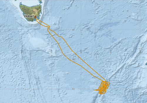
This record describes sub bottom profiler data collected on RV Investigator voyage IN2020_V06, titled "Probing the Australian-Pacific Plate Boundary: Macquarie Ridge in 3-D." The voyage took place between October 8 and November 3, 2020 departing from Hobart (TAS) and arriving in Hobart (TAS). The Kongsberg SBP120 (sub bottom profiler) was used to acquire data containing the specular reflections at different sediment interfaces below the seafloor. The SBP120 provides a 3° by 3° angular resolution. The echosounder's frequency sweep range is from 2.5 to 7 kHz. The SBP120 was logged continuously for the extent of the voyage. The data collected was suitable for the tasks required surrounding Macquarie Island itself, but was of mostly low quality surrounding steep dipping terrain and the Macquarie ridge itself. Data are stored in *.raw (3,465 files 14.4 GB) raw and *.seg (3,502 files 14.4 GB) segy formats at CSIRO. The segy format data had a real time processing stream applied, which applies gain, a gain correction, matched filter with replica shaping, an attribute calculation for instantaneous amplitude and time variable gain. Additional information regarding this dataset is contained in the GSM data acquisition and processing report. Additional data products may be available on request