Keyword
Earth Science | Oceans | Ocean Optics | Absorption
30 record(s)
Type of resources
Topics
Keywords
Contact for the resource
Provided by
Formats
Update frequencies
Status
draft
-
This record contains data collected from the near-water surface sampling site off the Lucinda Jetty, as part of the Lucinda Jetty Coastal Observatory. Sample collection began the 9th of January, 2014. The data can be used for Ocean Colour sensor validation. Parameters measured include the absorption coefficients of the particulate and dissolved components of the water column and the phytoplankton pigment concentration and composition.
-

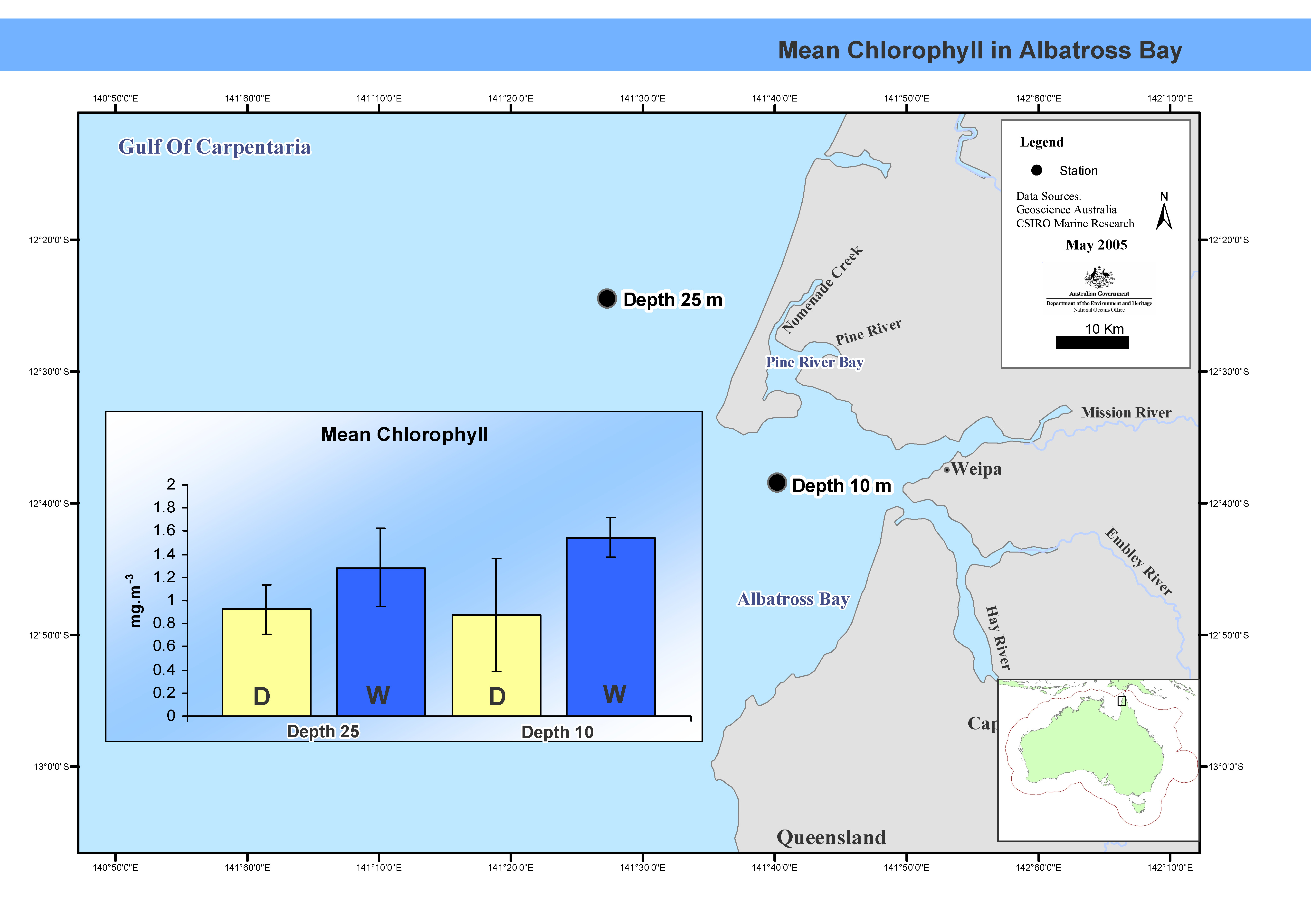
This map shows mean chlorophyll concentrations in Albatross Bay. Between February 1988 and February 1992 the FRV Jacqueline D completed nine cruises, seven in summer, two in winter, in Albatross Bay in the north-east Gulf of Carpentaria. Two stations, one 10m deep, the other at 25m, were sampled. Mean chlorophyl levels and primary productivity in the water column were measured. This map has been produced by CSIRO for the National Oceans Office, as part of an ongoing commitment to natural resource planning and management through the 'National Marine Bioregionalisation' project.
-

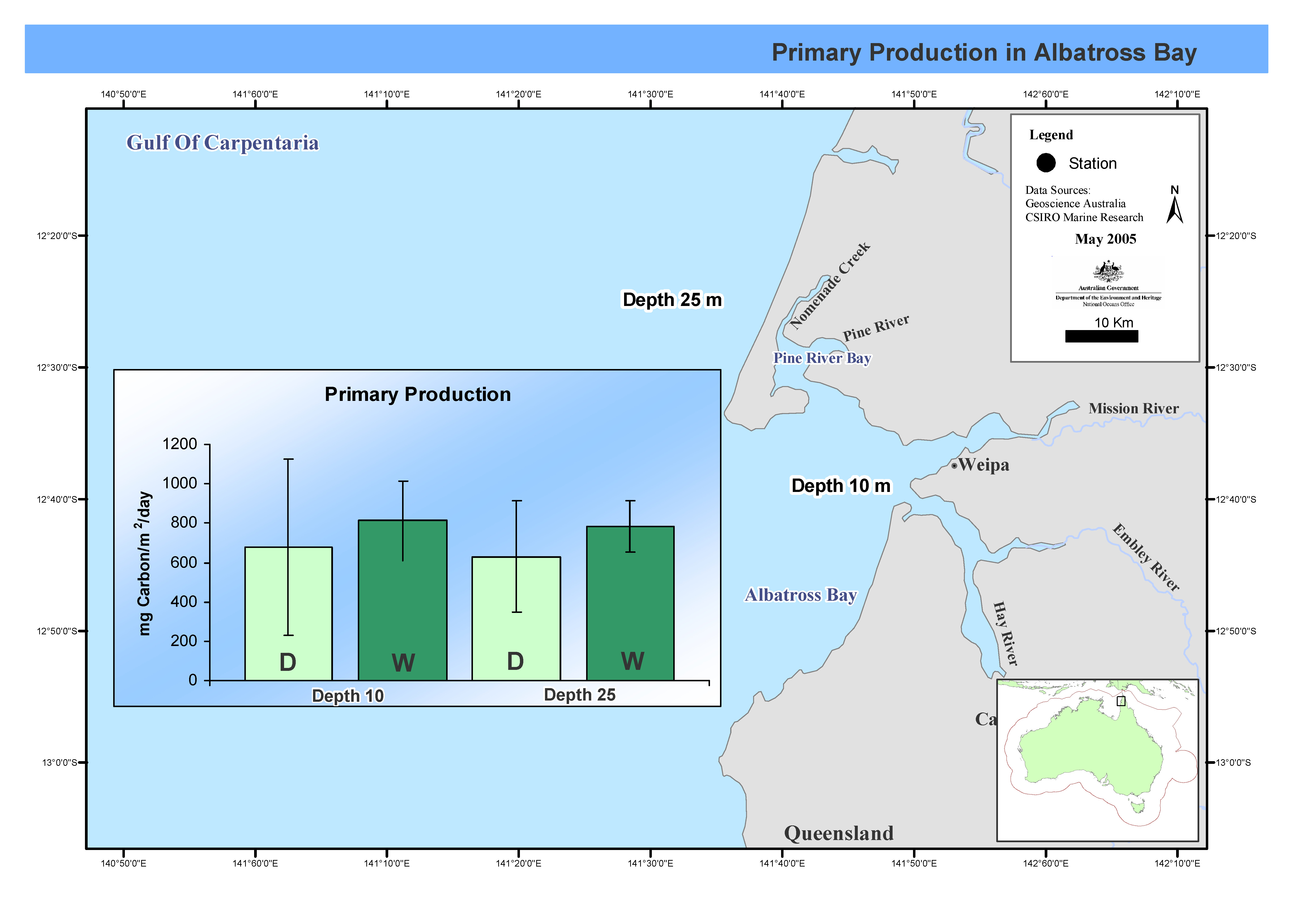
his map shows C14 primary productivity incubations at two stations over seven cruises in Albatross Bay during both the wet and dry seasons. Between February 1988 and February 1992 the FRV Jacqueline D completed nine cruises, seven in summer, two in winter, in Albatross Bay in the north-east Gulf of Carpentaria. Two stations, one 10m deep, the other at 25m, were sampled. Mean chlorophyll levels and primary productivity in the water column were measured. This map has been produced by CSIRO for the National Oceans Office, as part of an ongoing commitment to natural resource planning and management through the 'National Marine Bioregionalisation' project.
-
his movie file consists of a series of 8-day composite, 4 km resolution SeaWiFS surface chlorophyll images for the geographical area bounded by 90°E-180°E, and 10°N to 60°S. The data run from September 1997 until March 2001. Pixels where no usable data has been received are represented in black. A colour bar and calendar are included in the movie. Pixels where no usable data were received are represented by black dots. Accuracy is ± 20%. Each scene was captured as a gif image, and then assembled into a movie by Chris Rathbone, CSIRO Division of Marine Research Remote Sensing Group. The composite images were obtained from http://oceancolor.gsfc.nasa.gov/SeaWiFS/ .
-
This data is the surface solar irradiance data obtained for NASA/GISS to allow the production of photosynthetically active solar irradiance fields to allow the calculation of primary production using satellite ocean colour products. The information comes from the International Satellite Cloud Climatology Project (ISCCP) using C1 data from multiple geostationary and polar orbiting meteorological satellites to provide a global view of the occurrence and properties of clouds. Atmospheric, cloud and surface data from ICSSP are used as input along with a scheme for computing clear-sky irradiance from the solar zenith angle, air properties, and surface reflectance. The scheme then uses simple cloud properties (cloud fraction, cloud optical thickness, and diffuse albedo) to produce total and photosynthetically active solar irradiance fields (Bishop and Rossow 1991; ISCCP Documentation of Cloud Data; Frouin et al. 1989). Input and output data fields are given in a 2.5° latitude and longitude grid. Monthly output data averages have been used for this project.
-
This record contains data collected on the Lady Basten (AIMS cruise code LB2401/99) between 11 and 18 October 1999 from waters in the Great Barrier Reef near Rib Reef, Pandora Reef and Orpheus Island. The data can be used for Ocean Colour sensor validation. Parameters measured are the concentration of chlorophyll and carotenoid pigments and the absorption coefficient for dissolved (CDOM), particulate and detrital or non-algal components of the water column.
-
This record contains data collected on the charter vessel Maritime Image between 14 and 17 April 2003 off the southwest of Western Australia . The data can be used for Ocean Colour sensor validation. Parameters measured are the concentration of chlorophyll and carotenoid pigments and retrieved chlorophyll a estimate, the absorption coefficient for dissolved (CDOM) particulate (a/p) and detrital or non-algal (a/d) components of the water column. Eleven stations were sampled. The data was used primarily to alidate ocean colour sensors MERIS, MODIS and SeaWIFs and the SST sensor AATSR. Samples were collected and analysed for pigments, total suspended solids (TSS) and absorption coefficient, dissolved and particulate. CLW deployed instruments RAMSES, AC-9, Hydroscat and Hydrorad.
-
The Huon Estuary Study was undertaken by CSIRO Marine Research between 1996 and 1998. The Huon Estuary is in South Eastern Tasmania. This record references the optical absorption data from both the spatial (HES) and the weekly monitoring (CM) surveys of the Huon Estuary Study. This dataset includes phytoplankton, spectral absorption and HPLC pigments. Final data for the pigment and phytoplankton data has been stored within the HES database which has been refered to by metadata record 'Huon Estuary Study 1996/1998 - Database'. The final datasets have also been written to cdrom as text files for archiving purposes by the Data Centre, Hobart. The spectral absortion data is scheduled to be reworked and will be added to the archive when it becomes available.
-
The data were collected at 5 stations on the RV Southern Surveyor SS 01/2004 voyage in January 2004. The data were collected to determine the bio-optical charateristics of this region. The data can be used for Ocean Colour sensor validation. Parameters measured absorption coefficients of phytoplankton phytoplankton (aph) and non-algal or detrital matter (ad) in discrete sea-water samples, determined using a laboratory spectrophotometer. Also concentration of chlorophyll and carotenoid pigments were measured by High Performance Liquid Chromatography of pigments in discrete sea-water samples using the method of Van Heukelmen and Thomas 2001. This data was part of Strategic Research Fund for the Marine Environment (SRFME) project where samples were collected from Two Rocks offshore transect from coastal to offshore stations at five sites (A-E) during (Feb 2002 - Dec 2004). These sites were also sampled during Southern Surveyor Voyages SS07/2003, SS01/2004. Note sites A and B were the same locations from the Two Rocks coastal transect identified as T1 and T6 respectively in Marlin record 6819 SRFME Ocean Colour data. Microphytobenthos samples were collected at sites where Martin Lourey worked. Note that this record contains data for Voyage SS01/2004 only.
-
This record contains data collected at 7 stations on the Southern Surveyor cruise SS 01/99. Water samples were collected from an area of the Southern Ocean near MacQuarie Island to determine the bio-optical properties of water masses in these regions. The data can be used for Ocean Colour and CDOM sensor validation. Parameters measured are the concentration of chlorophyll and carotenoid pigments and the absorption coefficient for dissolved (CDOM) particulate (a/p) and detrital or non-algal (a/d) components of the water column. In addition to the station samples, 47 water samples were collected from the outflow of the underway fluorometer and analysed for the concentration of chlorophyll and carotenoid pigments only.
