
Keyword
Continents | Antarctica
32 record(s)
Type of resources
Topics
Keywords
Contact for the resource
Provided by
Formats
Update frequencies
Status
draft
-
This dataset contains data collected by the Australian Continuous Plankton Recorder (AusCPR) survey and is funded by IMOS (Ships of Opportunity sub-facility) and CSIRO. The aims of the AusCPR survey are to: * map plankton biodiversity and distribution * develop the first long-term plankton baseline for Australian waters * document plankton changes in response to climate change * provide indices for fisheries management * detect harmful algal blooms * validate satellite remote sensing * initialise and test ecosystem models. The survey conducts repeat tows in the GBR, the East Australian Current and down to the Southern Ocean Time Series Mooring (SOTS). Other routes are conducted on an adhoc nature around Australia. The dataset also contains phytoplankton data from the UTAS / AAD led Southern Ocean CPR (SOCPR) project which is also funded by IMOS. The datasets available in this collection include Phytoplankton Colour Index (an estimate of chlorophyll in the water), phytoplankton abundance, zooplankton abundance and a biomass index from AusCPR and phytoplankton abundance from SOCPR. This data are freely available through the AODN portal: https://portal.aodn.org.au. This data is freely available but please acknowledge all relevant parties, as detailed in acknowledgement section.
-
This collection includes ice cores and associated air samples from Antarctica and Greenland. Ice cores are collected from various sites including Law Dome Antarctica. Data files are kept on depth, age, chemical composition and gas compositions of the ice cores. The ice cores samples are archived and stored at Breeze Logistics (Cold Storage), Clayton, VIC. These samples are part of a series including Australian Antarctic Division Ice Cores (Hobart)and Greenland Ice Cores (Copenhagen). The data associated with this collection can be accessed through the World Data Center(WDC) for Paleoclimatology http://www.ngdc.noaa.gov/wdc/usa/paleo.html.
-
This record describes echosounder data collected on RV Investigator voyage IN2015_E01, which departed Hobart on the 29 Jan 2015 and returning to Hobart on the 19 Feb 2015, after successfully testing equipment at 65° south. The Simrad EK60 split beam echosounders 38, 70, 120, 200 and 333 KHz were used to acquire water column and bathymetry data between Hobart and Antarctica. Data are stored in *.raw *.bot and *.idx format at CSIRO Oceans and Atmosphere. There are 906 files totalling 43.1 GB of raw data in this dataset. Additional information regarding this dataset is contained in the GSM data acquisition and processing report.
-
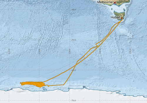
This record describes multibeam echosounder data collected on RV Investigator voyage IN2017_V01, 'Interactions of the Totten Glacier with the Southern Ocean through multiple cycles. ‘Sabrina Seafloor Survey' which departed Hobart on the 14th January 2017 and returned to Hobart on the 5th March 2017. The Kongsberg EM710 MKII multibeam echosounder was used to acquire seafloor bathymetry and backscatter information between Hobart and Totten Glacier. The EM710 MKII provides a 0.5° by 1° transmit and receive angular resolution respectively. The echosounder's nominal frequency range is from 40 to 100 kHz. Data are stored in *.all raw format for bathymetry and backscatter and *.wcd format for watercolumn backscatter at CSIRO. There are 71 files totalling 12 GB of raw data in this dataset. Sound velocity profiles were applied to this data during data acquisition. Bathymetry data contained in *.all format are corrected for motion and position. Tide corrections were not applied to the processed data. Processed data has had outliers removed. Processed line data are available in *.gsf and ascii format, and processed bathymetry and backscatter grids in geotiff format. Additional information regarding this dataset, including further information on processing streams, is contained in the GSM data acquisition and processing report. Additional data products may be available on request.
-
This record describes multibeam echosounder data collected on RV Investigator voyage IN2015_E01, which departed Hobart on the 29 Jan 2015 and returned to Hobart on the 19 Feb 2015, after successfully testing equipment at 65° south. The Kongsberg EM122 multibeam echosounder was used to acquire seafloor bathymetry and backscatter information in from Hobart to Antarctic waters. Ping rate varied according to depth. Data are stored in *.all raw format at CSIRO Oceans and Atmosphere. There are 389 files totalling 11.4 GB of raw data in this dataset. Sound velocity profiles were applied to this data during data acquisition. Tide corrections were not applied to the processed data. Additional information regarding this dataset is contained in the GSM data acquisition and processing report. Additional data products available on request.
-
This record describes multibeam echosounder data collected on RV Investigator voyage IN2017_V01, 'Interactions of the Totten Glacier with the Southern Ocean through multiple cycles. ‘Sabrina Seafloor Survey' which departed Hobart on the 14th January 2017 and returned to Hobart on the 5th March 2017. The Kongsberg EM122 multibeam echosounder was used to acquire seafloor bathymetry, backscatter information between Hobart and Totten Glacier. The EM122 provides a 1 degree by 1 degree angular resolution. The echosounder's nominal frequency is 12 kHz. Data are stored in *.all raw format for bathymetry and backscatter and *.wcd format for watercolumn backscatter at CSIRO. There are 1310 files totalling 32.9 GB of raw data in this dataset. Sound velocity profiles were applied to this data during data acquisition. Bathymetry data contained in *.all format are corrected for motion and position. Tide corrections were not applied to the processed data. Processed data had outliers removed. Processed line data are available in *.gsf and ascii format, and processed bathymetry and backscatter grids in geotiff format. Additional information regarding this dataset, including information on processing streams, is contained in the GSM data acquisition and processing report. Additional data products may be available on request.
-
This record describes scientific split-beam echosounder data collected on the RV Investigator voyage IN2017_V01, 'Interactions of the Totten Glacier with the Southern Ocean through multiple cycles. ‘Sabrina Seafloor Survey' which departed Hobart on the 14th January 2017 and returned to Hobart on the 5th March 2017. The Simrad EK60 split beam echosounders 18, 38, 70 120, 200 and 333 kHz were used to acquire acoustic backscatter data to a range of 1500 m, between Hobart and Totten Glacier. All frequencies were logged continuously for the extent of the voyage. Data are stored in *.raw, *.bot and *.idx format at CSIRO. There are 1120 files totalling 31.5 GB of raw data in this dataset. No processing has been conducted on this data. Additional information regarding this dataset is contained in the GSM data acquisition and processing report. Additional data products may be available on request.
-
This record describes sub bottom profiler data collected on RV Investigator voyage IN2017_V01, 'Interactions of the Totten Glacier with the Southern Ocean through multiple cycles. ‘Sabrina Seafloor Survey' which departed Hobart on the 14th January 2017 and returned to Hobart on the 5th March 2017. The Kongsberg SBP120 (sub bottom profiler) was used to acquire data containing the specular reflections at different sediment interfaces below the seafloor. The SBP120 provides a 3° by 3° angular resolution. The echosounder's frequency sweep range is from 2.5 to 7 kHz. The SBP120 was logged continuously for the extent of the voyage. Data are stored in *.raw (381 files 5.81 GB) raw and *.seg (220 files 3.62 GB) segy formats at CSIRO. The segy format data had a real time processing stream applied, which applies gain, a gain correction, matched filter with replica shaping, an attribute calculation for instantaneous amplitude and time variable gain. Additional information regarding this dataset is contained in the GSM data acquisition and processing report. Additional data products may be available on request
-
This record describes gravity data collected on RV Investigator voyage IN2017_V01, 'Interactions of the Totten Glacier with the Southern Ocean through multiple cycles. ‘Sabrina Seafloor Survey' which departed Hobart on the 14th January 2017 and returned to Hobart on the 5th March 2017. The gravity meter instrument is a MicroG Lacoste Air-Sea II. Data are stored in .ENV and .DAT data files at CSIRO. There are 49 files totalling 796 MB of raw data in this dataset. Wharf ties were undertaken at the CSIRO wharf in Hobart using a Scintrex Autograv CG-5. No processing has been conducted on this data. Additional information regarding this dataset is contained in the GSM data acquisition and processing report.
-
This record describes XBT data collected on RV Investigator voyage IN2017_V01, 'Interactions of the Totten Glacier with the Southern Ocean through multiple cycles. ‘Sabrina Seafloor Survey' which departed Hobart on the 14th January 2017 and returned to Hobart on the 5th March 2017'. A total of 28 XBT casts were conducted over the duration of this voyage. Data are stored in netCDF files at CSIRO. Additional information regarding this dataset is contained in the GSM data acquisition and processing report. Additional data products may be available on request.