Keyword
Earth Science | Oceans | Ocean Circulation | Turbulence
6 record(s)
Type of resources
Topics
Keywords
Contact for the resource
Provided by
Formats
Update frequencies
Status
draft
-

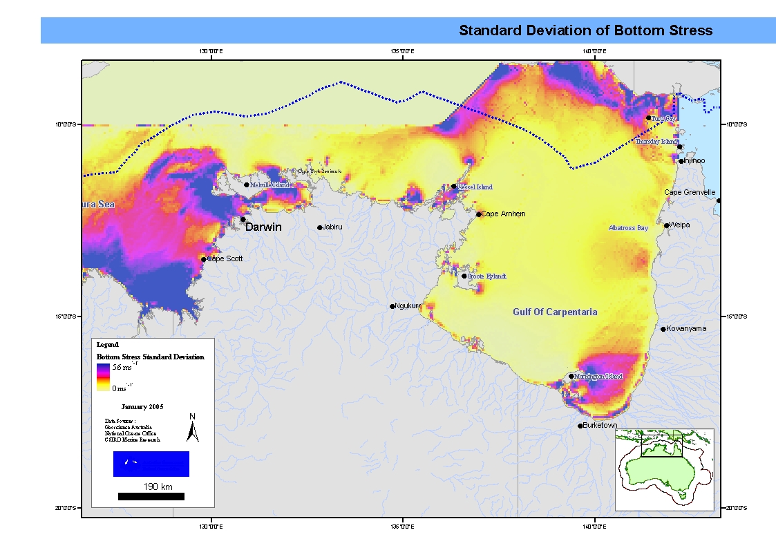
Mapset showing maximum, mean and standard deviation bottom stress in the Northern Marine Region. This map has been produced by CSIRO for the National Oceans Office, as part of an ongoing commitment to natural resource planning and management through the 'National Marine Bioregionalisation' project.
-
OFAM is based on version 4.0d of the Modular Ocean Model, using a hybrid mixed layer model. The horizontal grid has 1191 and 968 points in the zonal and meridional directions respectively; with 1/10 degree horizontal resolution around Australia (90-180E, south of 17). Outside of this domain, the horizontal resolution decreases to 0.9 degrees across the Pacific and Indian basins (to 10E, 60W and 40N) and to 2 degrees in the Atlantic Ocean. OFAM has 47 vertical levels, with 10 m resolution down to 200 m depth. The topography for OFAM is a composite of topography sources including dbdb2 and GEBCO. Horizontal diffusion is zero. Horizontal viscosity is resolution and state-dependent according to the Smagorinsky viscosity scheme (Griffies and Hallberg 2000). BRAN is a multi-year integration of OFAM that assimilates observations using an ensemble optimal interpolation (EnOI) scheme that uses a stationary ensemble of intraseasonal model anomalies, obtained from a non-assimilating model run. Observations include along-track SLA (atSLA) from altimeters and tide gauges, in situ T and S observations and satellite SST.
-
This dataset contains temperature data from the West Indian Ocean. Data (including available XBT data) were collected since 1778. They have been subjected to quality control as an activity of CSIRO and BoM.
-
Algorithms are presented for density, potential temperature, conservative temperature, and the freezing temperature of seawater. The algorithms for potential temperature and density (in terms of potential temperature) are updates to routines recently published by McDougall et al., while the algorithms involving conservative temperature and the freezing temperatures of seawater are new. The McDougall et al. algorithms were based on the thermodynamic potential of Feistel and Hagen; the algorithms in this study are all based on the "new extended Gibbs thermodynamic potential of seawater" of Feistel. The algorithm for the computation of density in terms of salinity, pressure, and conservative temperature produces errors in density and in the corresponding thermal expansion coefficient of the same order as errors for the density equation using potential temperature, both being twice as accurate as the International Equation of State when compared with Feistel's new equation of state. An inverse function relating potential temperature to conservative temperature is also provided. The difference between practical salinity and absolute salinity is discussed, and it is shown that the present practice of essentially ignoring the difference between these two different salinities is unlikely to cause significant errors in ocean models.
-
INSTANT: A New International Array to Measure the Indonesian Throughflow. The INSTANT field program (International Nusantara Stratification And Transport) began in August 2003 and consists of a 3-year deployment of an array of moorings and coastal pressure gauges that will directly measure sea level and full depth in situ velocity, temperature, and salinity of the ITF. For the first time, simultaneous, multipassage, multiyear measurements will be available, and allow the magnitude and properties of the interocean transport between the Pacific and Indian Oceans to be unambiguously known. The array will also provide an unprecedented data set revealing how this complex and fascinating region responds to local and remote forcing at many timescales never before well resolved. Moorings were located at the following locations: (115 45.48, 8 26.77) (115 53.77, 8 24.56) (122 58.36, 11 31.76) (122 57.40, 11 22.19) (122 51.5, 11 16.6) (122 46.8, 11 9.67) (125 32.26, 8 32.33) (125 2.26, 8 24.04)
-
This record describes the End of Voyage (EOV) archive from the Marine National Facility RV Investigator research voyage in2016_v03, titled "Monitoring Ocean Change and Variability along 170 W from the ice edge to the equator." The voyage consisted of two legs: Leg 1 from Hobart (TAS) to Wellington (NZ) between April 27 and May 26, and Leg 2 from Wellington (NZ) to Lautoka (Fiji) from April 27 to June 28, 2016. Main project: "Monitoring Ocean Change and Variability along 170oW from the ice edge to the equator." Supplementary project: "Facing the challenges of under-ice for autonomous navigation." For further information refer to the Voyage documentation links below. Data collected include: Acoustic Doppler Current Profiler (ADCP; 75, 150 KHz and LADCP), Scanning Mobility Particle Sizers (SMPS), Disdrometer, Oxygen, Radon, and Greenhouse (Aerodyne and Picarro) sensors, CTD, Hydrochemistry, Gravitometer, Fisheries Echosounder (EK60), Multibeam Echosounder (EM122, EM710, SBP120), Weather Radar, XBT. Voyage-specific data include: Sea-ice measurements, Aerosol Chemical Speciation Monitor (ACSM), Aerosol Aerodynamic Particle sizer (APS), Carbon sensor, Cloud Condensation Nuclei counter (CCN), Chlorofluorocarbons/Sulfur Hexafluoride/Nitrogen Oxides sensor(CFC SF6 Nox), Turbulence Chipods, Condensation Particle counter (CPC), Micro Rain Radar (MRR), Microwave Radiometer (MWR), Neutral cluster Air Ion Spectrometer (NAIS), Proton-transfer-reaction mass spectrometer (PTR-MS), FOG-based High-performance Inertial Navigation System (PHINS INS), Volatile Organic Compounds (VOC) sensor, Gas Chromatograph (SEQ), Volatility-Hygroscopicity Tandem Differential Mobility Analyser (VHTDMA). The archive for the IN2016_V03 EOV data is curated by the CSIRO Oceans and Atmosphere Data Centre in Hobart, with a permanent archive at the CSIRO Data Access Portal (DAP, https://data.csiro.au/dap/), providing access to participants and processors of the data collected in the Marine National Facility RV Investigator IN2016_V03 voyage. All voyage documentation is available electronically to MNF support via the local network. Access to voyage documentation for non-CSIRO participants can be made via DataLibrariansOAMNF@csiro.au. All processed data from this voyage are made publicly available through the MNF Data Trawler (in the related links).
