
eReefs GBR4 river tracers v2.0
Passive river tracer results derived from version 2.0 of the 4km-resolution regional-scale hydrodynamic model of the Great Barrier Reef (GBR4).
This model configuration and associated results dataset may be referred to as "GBR4_H2p0_Rivers" according to the eReefs simulation naming protocol.
The model ran in near-real-time mode, updating daily, until January 2024 when the 2023/24 monsoon season caused damage to sensors in the catchments, and we lost access to the critical river-flow forcing dataset.
Simple
Identification info
- Alternate title
-
GBR4_H2p0_Rivers
- Alternate title
-
GBR4 Rivers v2.0 NRT
- Date
- Credit
-
CSIRO Coastal Environmental Modelling Team
- Credit
-
Australian Institute of Marine Science (AIMS)
- Credit
-
Bureau of Meteorology (BOM)
- Credit
-
Great Barrier Reef Marine Park Authority (GBRMPA)
- Credit
-
James Cook University (JCU)
- Credit
-
Queensland Government Department of Environment and Science (DES)
- Status
- Completed
- Point of contact
-
Role Organisation Electronic mail address Custodian CSIRO eReefs Operations Team
Publisher NCI Australia
ipOwner Commonwealth Scientific and Industrial Research Organisation (CSIRO)
Funder Commonwealth Scientific and Industrial Research Organisation (CSIRO)
Funder Great Barrier Reef Foundation (GBRF)
Author CSIRO Coastal Environmental Modelling Team
Co-author Australian Institute of Marine Science (AIMS)
Co-author Bureau of Meteorology (BOM)
Co-author Great Barrier Reef Marine Park Authority (GBRMPA)
Co-author James Cook University (JCU)
Co-author Queensland Government Department of Environment and Science (DES)
- Topic category
-
- Oceans
- Environment
Extent
))
Temporal extent
- Time position
- 2010-12-01
- Time position
- 2024-01-17
- Maintenance and update frequency
- As needed
- AODN Geographic Extent Names
- CSIRO Project List
Resource constraints
Resource constraints
- Use limitation
-
Please cite as "CSIRO Coastal Environmental Modelling, Australian Institute of Marine Science, Bureau of Meteorology, Great Barrier Reef Marine Park Authority, James Cook University, Queensland Government Department of Environment and Science (2016): GBR3_H2p0_Rivers, eReefs GBR4 river tracers v2.0 (Collection). NCI Australia."
Resource constraints
- Use limitation
-
The Data are available is for general informational purposes only, and are not intended to provide any commercial, financial, legal or navigational advice. The Data may not be appropriate to your individual needs. You must exercise your own independent, skill, care and judgment with respect to how you use the Data.
- Language
- English
- Character encoding
- UTF8
- Supplemental Information
-
The marine modelling component of eReefs was tasked to deliver numerical models capable of simulating and predicting the physical hydrodynamic state, sediment transport, water quality and basal ecology of the Great Barrier Reef (GBR) lagoon and reef matrix. Together, these models represent a capability to simulate the transport and fate of waterborne material, of either oceanic or terrestrial origin, and its impact on Reef water quality. The numerical models are built using CSIRO’s Environmental Modelling Suite, and include regional 4 km and 1 km resolution models.
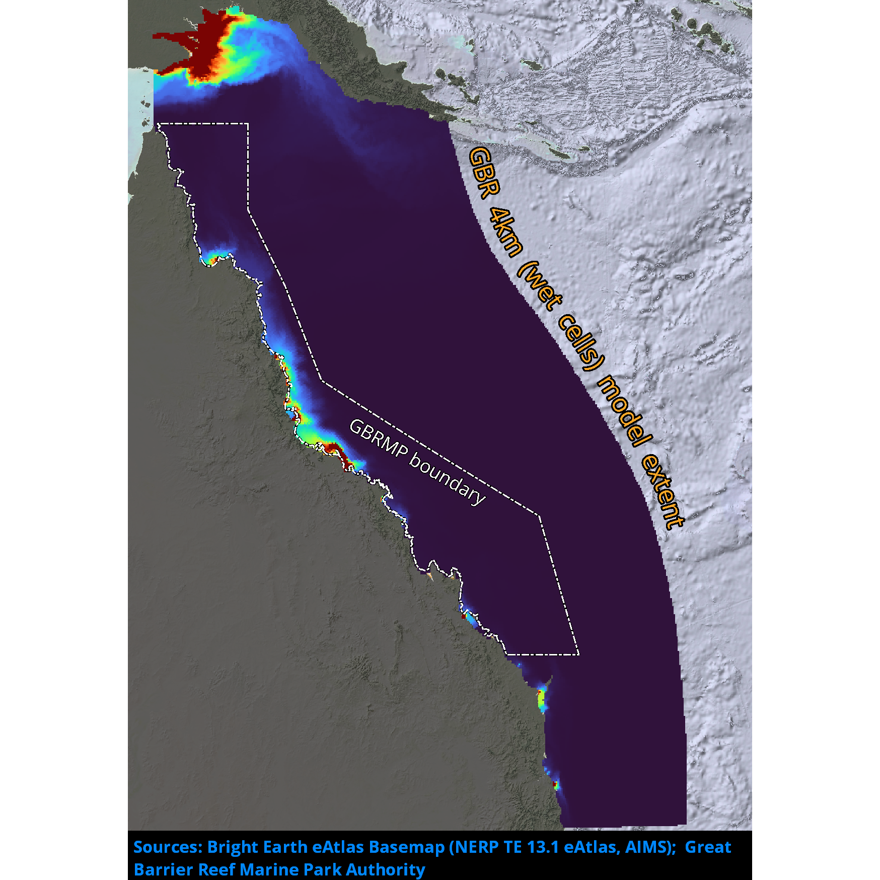
The 4 km resolution model (GBR4 regional model) is intended to simulate the dominant oceanographic processes impacting on the GBR shelf. The 4 km grid (GBR4) has 180 x 600 cells, including 44 vertical layers with 1 m resolution at the surface.
The 1 km resolution model (GBR1 shelf model) is nested within the 4 km model (GBR4) and began routine operation in December 2014. The 1 km grid (GBR1) is extremely large, with 510 x 2390 cells, including 48 vertical layers with 1 m resolution at the surface.
The product is CF 1.0 compliant.
Distribution Information
- Distribution format
-
-
DIGITAL - OGC OWS Context
-
DIGITAL - netCDF
-
- OnLine resource
-
eReefs Models
Web page with information about the eReefs Regional Models and the science behind them
- OnLine resource
-
Environmental Modelling Suite (EMS)
Web page with links and downloads to documentation and manuals for components of the Environmental Modelling Suite (EMS).
- OnLine resource
-
THREDDS Catalog entry for GBR4_H2p0_Rivers results aggregation
THREDDS timeseries aggregation of the entire dataset with access via OPeNDAP, WMS, WCS, NetcdfSubset
- OnLine resource
-
OGC Web Map Service for GBR4_H2p0_Rivers parameter layers
OGC Web Map Service (WMS) endpoint with CF-compliant NetCDF Extensions enabled
- OnLine resource
-
THREDDS Catalog for GBR4_H2p0_Rivers results files
THREDDS catalog of individual results files with access via OPeNDAP, WMS, WCS, NetcdfSubset
- OnLine resource
-
eReefs Data Broker API entry for GBR4_H2p0_Rivers
eReefs Data Broker REST API with access to metadata as JSON, JSON-LD, RDF, TTL depending on content-type header.
- OnLine resource
-
NCI Data Catalogue
Metadata entry for this dataset in the NCI Data Catalogue
Data quality info
- Hierarchy level
- Dataset
Report
Result
- Explanation
-
The product is CF 1.0 compliant
Resource lineage
- Statement
-
These data are output from high-resolution ocean models including hydrological processes.
- Hierarchy level
- Dataset
Reference System Information
- Reference system identifier
- EPSG/WGS 84 (EPSG:4326)
Metadata
- Metadata identifier
- urn:uuid/fc5ad4ec-6777-4855-969e-6b29dbf1e122
- Language
- English
- Character encoding
- UTF8
- Contact
-
Role Organisation Electronic mail address Processor CSIRO
Point of contact CSIRO Oceans & Atmosphere - Hobart
Originator CSIRO
Type of resource
- Resource type
- Dataset
- Metadata linkage
-
https://marlin.csiro.au/geonetwork/srv/eng//metadata/d2ff17de-8347-4213-b59d-ab9afeb0b899
- Date info (Creation)
- 2026-02-27T02:40:38.735088Z
- Date info (Creation)
- 2021-11-12T03:09:19
- Date info (Revision)
- 2026-02-27T02:42:30.521374Z
Metadata standard
- Title
-
ISO 19115-3:2018
- Title
-
Marine Community Profile
- Date (Creation)
- 2019-05-30
- Edition
-
3.0
- Edition date
- 2019-05-30T00:00:00
- Cited responsible party
-
Role Organisation Electronic mail address Custodian Marine Community Profile Governance Committee
)))