WITHDRAWN: eReefs GBR1 biogeochemistry and sediments v3.2
***This dataset was retired by its authors in February 2026 because the model used to generate it was discovered to have an error which lead to abnormally high/unrealistic Chlorophyll-a levels on the shelf edge and reef matrix. The values in the results dataset are not only inconsistent with the more recent GBR4_H4p0_ABARRAr2_OBRAN2020_FG2Gv3_B4p2_Cq5b_Dhnd dataset, but also scientifically unreasonable for these areas, where Chla should generally be ≤0.5 mg m⁻³ based on coral sea observations. Researchers should discontinue any use of this dataset as soon as possible.***
Results from version 3.2 of the 1km-resolution regional-scale biogeochemistry and sediments model of the Great Barrier Reef (GBR1), forced by version 2.0 of the 1km-resolution hydrodynamic model and with Furnas relationships for wet and dry tropics rivers as catchment inputs.
This model configuration and associated results dataset may be referred to as "GBR1_H2p0_B3p2_Cfur_Dnrt" according to the eReefs biogeochemical simulation naming protocol.
The model ran in near-real-time mode, updating daily, until January 2024 when the 2023/24 monsoon season caused damage to sensors in the catchments, and we lost access to the critical river-flow forcing dataset.
Simple
Identification info
- Alternate title
-
GBR1_H2p0_B3p2_Cfur_Dnrt
- Alternate title
-
GBR1 BGC v3.2 NRT
- Date
- Credit
-
CSIRO Coastal Environmental Modelling Team
- Credit
-
Australian Institute of Marine Science (AIMS)
- Credit
-
Bureau of Meteorology (BOM)
- Credit
-
Great Barrier Reef Marine Park Authority (GBRMPA)
- Credit
-
James Cook University (JCU)
- Credit
-
Queensland Government Department of Environment and Science (DES)
- Status
- Withdrawn
- Point of contact
-
Role Organisation Electronic mail address Custodian CSIRO eReefs Operations Team
Publisher NCI Australia
ipOwner Commonwealth Scientific and Industrial Research Organisation (CSIRO)
Author CSIRO Coastal Environmental Modelling Team
Co-author Australian Institute of Marine Science (AIMS)
Queensland Government Department of Environment and Science (DES)
Co-author Bureau of Meteorology (BOM)
Co-author Great Barrier Reef Marine Park Authority (GBRMPA)
Co-author James Cook University (JCU)
Co-author Queensland Government Department of Environment and Science (DES)
Funder Great Barrier Reef Foundation (GBRF)
Funder Commonwealth Scientific and Industrial Research Organisation (CSIRO)
- Topic category
-
- Oceans
- Environment
Extent
))
Temporal extent
- Time position
- 2019-10-16
- Time position
- 2024-01-16
Identifier
- Codespace
-
doi
- Maintenance and update frequency
- As needed
- AODN Geographic Extent Names
- CSIRO Project List
- GCMD Keywords
-
- Earth Science Services | Models | Ocean General Circulation Models (Ogcm)/Regional Ocean Models
- Earth Science Services | Models | Earth Science Reanalyses/Assimilation Models
- Earth Science | Biosphere | Aquatic Ecosystems | Reef Habitat
- Earth Science | Oceans | Coastal Processes | Coral Reefs
- Earth Science | Oceans | Marine Sediments
- Earth Science | Biosphere | Aquatic Ecosystems | Benthic Habitat
- Earth Science | Oceans | Ocean Chemistry
- Earth Science | Biosphere | Aquatic Ecosystems | Plankton
- Earth Science | Oceans | Ocean Optics
Resource constraints
Resource constraints
- Use limitation
-
Please cite as "CSIRO Coastal Environmental Modelling, Australian Institute of Marine Science, Bureau of Meteorology, Great Barrier Reef Marine Park Authority, James Cook University, Queensland Government Department of Environment and Science (2022): GBR1_H2p0_B3p2_Cfur_Dnrt, eReefs GBR1 biogeochemistry and sediments v3.2 (Collection). NCI Australia"
Resource constraints
- Use limitation
-
The Data available is for general informational purposes only, and is not intended to provide any commercial, financial, legal or navigational advice. The Data may not be appropriate to your individual needs. You must exercise your own independent, skill, care and judgment with respect to how you use the Data.
- Language
- English
- Character encoding
- UTF8
- Supplemental Information
-
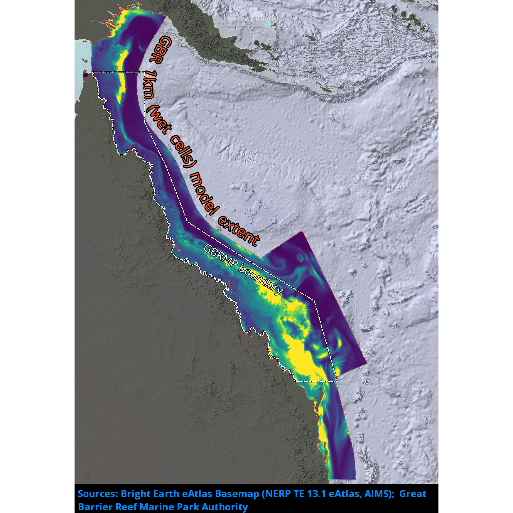
The marine modelling component of eReefs was tasked to deliver numerical models capable of simulating and predicting the physical hydrodynamic state, sediment transport, water quality and basal ecology of the Great Barrier Reef (GBR) lagoon and reef matrix. Together, these models represent a capability to simulate the transport and fate of waterborne material, of either oceanic or terrestrial origin, and its impact on Reef water quality. The numerical models are built using CSIRO’s Environmental Modelling Suite (EMS), and include regional 4 km and 1 km resolution models.
The 4 km resolution model (GBR4 regional model) is intended to simulate the dominant oceanographic processes impacting on the GBR shelf. The 4 km grid (GBR4) has 180 x 600 cells, including 44 vertical layers with 1 m resolution at the surface.
The 1 km resolution model (GBR1 shelf model) is nested within the 4 km model (GBR4) and began routine operation in December 2014. The 1 km grid (GBR1) is extremely large, with 510 x 2390 cells, including 48 vertical layers with 1 m resolution at the surface.
The product is CF 1.0 compliant.
Distribution Information
- Distribution format
-
-
DIGITAL - OGC OWS Context
-
DIGITAL - netCDF
-
- OnLine resource
-
eReefs Models
Web page with information about the eReefs Regional Models and the science behind them
- OnLine resource
-
Environmental Modelling Suite (EMS) documentation
Web page with links and downloads to documentation and manuals for components of the Environmental Modelling Suite (EMS)
- OnLine resource
-
NCI Data Catalogue
Metadata record for this dataset in the NCI Data Catalogue
Data quality info
- Hierarchy level
- Dataset
Report
Result
- Explanation
-
The product is CF 1.0 compliant
Resource lineage
- Statement
-
These data are output from high-resolution ocean models including hydrological, biogeochemical and sediment processes.
- Hierarchy level
- Dataset
Reference System Information
- Reference system identifier
- EPSG/WGS 84 (EPSG:4326)
Metadata
- Metadata identifier
- urn:uuid/85241b4c-4106-4a9d-992b-a77ee8c615ff
- Language
- English
- Character encoding
- UTF8
- Contact
-
Role Organisation Electronic mail address Processor CSIRO
Point of contact CSIRO Oceans & Atmosphere - Hobart
Originator CSIRO
Type of resource
- Resource type
- Dataset
- Metadata linkage
-
https://marlin.csiro.au/geonetwork/srv/eng//metadata/7bc0d1fc-d0e4-4c1a-956f-8f7cd1a6892d
- Date info (Creation)
- 2026-02-26T07:27:32.810907Z
- Date info (Creation)
- 2022-04-05T09:56:27
- Date info (Revision)
- 2026-02-26T07:41:07.776652Z
Metadata standard
- Title
-
ISO 19115-3:2018
- Title
-
Marine Community Profile
- Date (Creation)
- 2019-05-30
- Edition
-
3.0
- Edition date
- 2019-05-30T00:00:00
- Cited responsible party
-
Role Organisation Electronic mail address Custodian Marine Community Profile Governance Committee
Overviews
Spatial extent
)))
Provided by
