
Multichannel Seismic Reflection (MCS) Data from RV Investigator Voyage IN2020_V01
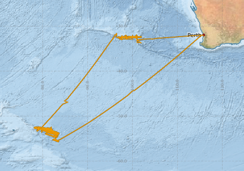
This record describes the Multichannel Seismic Reflection (MCS) dataset acquired during Marine National Facility voyage IN2020_V01 aboard the RV Investigator between 10 January and 6 March 2020. The survey formed part of the project investigating the development of William's Ridge and the Kerguelen Plateau, with objectives including understanding regional tectonic evolution, hotspot magmatism, microcontinental fragments, and Australia's Extended Continental Shelf. Nine seismic profiles were collected, with Profiles 0001–0004 imaging the upper crustal structure of William's Ridge and Profiles 0005–0009 imaging Broken Ridge. The dataset is provided in SEG-Y format, the industry standard for seismic reflection data, and can be visualised using compatible seismic interpretation software such as SeiSee. Seismic sections are displayed in two-way travel time (TWT; seconds or milliseconds), with spatial referencing provided in UTM Easting and Northing coordinates together with Common Depth Point (CDP) numbering. This dataset supports investigations of crustal structure, tectonic processes, and magmatic evolution across the southern Kerguelen Plateau region.
Simple
Identification info
- Date
- Status
- Completed
- Point of contact
-
Role Organisation Electronic mail address Point of contact CSIRO NCMI - Information and Data Centre
Custodian Mike Coffin (University of Tasmania)
- Topic category
-
- Oceans
Extent
))
Temporal extent
- Time position
- 2020-01-10
- Time position
- 2020-03-06
Resource constraints
- Language
- English
- Character encoding
- UTF8
Distribution Information
- OnLine resource
-
Marine National Facility
Link to the Marine National Facility Webpage
- OnLine resource
-
Access and download the Data from AAD
- OnLine resource
-
MNF Data Trawler
Link to processed data and survey information (plans, summaries, etc.) via MNF Data Trawler
Data quality info
- Hierarchy level
- Dataset
Resource lineage
- Hierarchy level
- Dataset
Reference System Information
- Reference system identifier
- EPSG/WGS 84 (EPSG:4326)
Metadata
- Metadata identifier
- 737b894b-a40f-4895-b4b8-be407d3600ba
- Language
- English
- Character encoding
- UTF8
- Contact
-
Role Organisation Electronic mail address Point of contact CSIRO NCMI - Information and Data Centre
Type of resource
- Resource type
- Dataset
- Metadata linkage
-
http://marlin.csiro.au/geonetwork/srv/api/records/737b894b-a40f-4895-b4b8-be407d3600ba
- Date info (Creation)
- 2026-06-30T02:38:57.08352Z
- Date info (Creation)
- 2026-06-30T00:04:52.1277Z
- Date info (Creation)
- 2026-04-28T01:21:11.360949Z
- Date info (Revision)
- 2026-06-30T02:52:33.116942Z
Metadata standard
- Title
-
ISO 19115-3:2018
- Title
-
Marine Community Profile
- Date (Creation)
- 2019-05-30
- Edition
-
3.0
- Edition date
- 2019-05-30T00:00:00
- Cited responsible party
-
Role Organisation Electronic mail address Custodian Marine Community Profile Governance Committee
)))
